


Could We Be Building Highways 15 Feet Above Ground Sometime Soon?
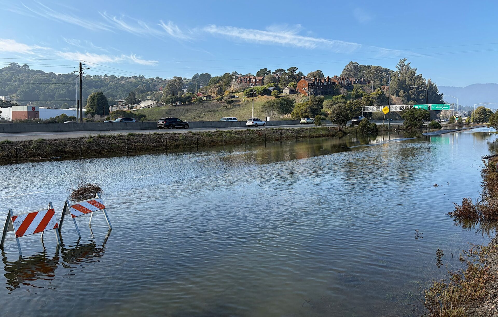
Highway 101 in Marin County during King Tides. Photo: Caltrans
Infrastructure built long ago along low-lying coastal lands has become a rising liability for Caltrans. Flooding of roads, bridges, bikeways and walking trails is becoming more frequent and extreme–a trend that tracks with every projection of rising sea level. Already,the ocean along California’s coast has risen by several inches since 2000, and by 2050 it will have gained several more.
With the help of design consulting firm Arup, Caltrans (the California Department of Transportation) has developed a statewide risk assessment of infrastructure in need of modification, protection, fortification, or other improvements to manage the effects of climate change, including but not limited to rising sea level. The assessment covers some 13,000 bridges, 275,000 culverts, and 53 tunnels. It reviews options for protecting structures with nature-based solutions, like vegetated sand dunes and cobble berms, and looks at least as far forward as the year 2100.
In the Bay Area, sites of particular concern include the east end of the Bay Bridge, where it touches down in Oakland, and the Highway 101 freeway as it cuts across southern Marin, between Sausalito and San Rafael.
Meg Ackerson, a senior coastal resilience engineer with Arup, is working with Caltrans to plan major infrastructure upgrades with a roughly 100-year lifespan at these sites and others statewide. With the best available science suggesting the ocean’s surface will be anywhere from 3.1 feet to 6.6 feet higher by the end of this century, the race is on to go big and build — or at least plan — quickly.
Even on the trajectory of a moderate scenario, Ackerson says, “we’ll reach six to seven feet by 2130.” With the added stressors of winter storm surges, large waves, and powerful El Niños, which can push long-duration, foot-high Kelvin waves up the West Coast, “you’re looking at building something that’s like 15 feet higher … maybe 20 feet higher, than … the ground around us.”
Other Recent Posts
Your Nine-County Guide to Bay Area Storm Prep
KneeDeep has you covered with this nine-county list of resources available in case of storm-related emergencies this winter.
Check Your Project Status: It’s All Here
The Bay Adapt Project and Funding Navigator is a first-of-its-kind, one-stop shop where everyone can find project statuses and funding ideas.
A Man Who Wears Many Hats
The leader of the San Mateo RCD’s Forest Health and Fire program says his mantra is to “be open to being wrong.”
Solano Samples Air And Finds Dirt
After helping shut down a polluting Vallejo cement plant, residents are working to expand community-led air quality monitoring across Solano County.
Who’s In Charge? What Projects Make the Cut?
The region has made progress planning for sea level rise, but who will coordinate a $100 billion effort over the coming decades remains an open question.
A Bulwark for San Francisco’s Skyscrapers?
A new joint federal and local plan maps out 13 strategies to protect 7.5 miles of San Francisco’s waterfront from sea level rise and future flooding.
Will El Niño Winter Bring Climate Chickens Home to Roost?
A dangerous combination of warm Pacific waters, Kelvin waves, king tides, and storms could disrupt life and infrastructure across the region this winter.
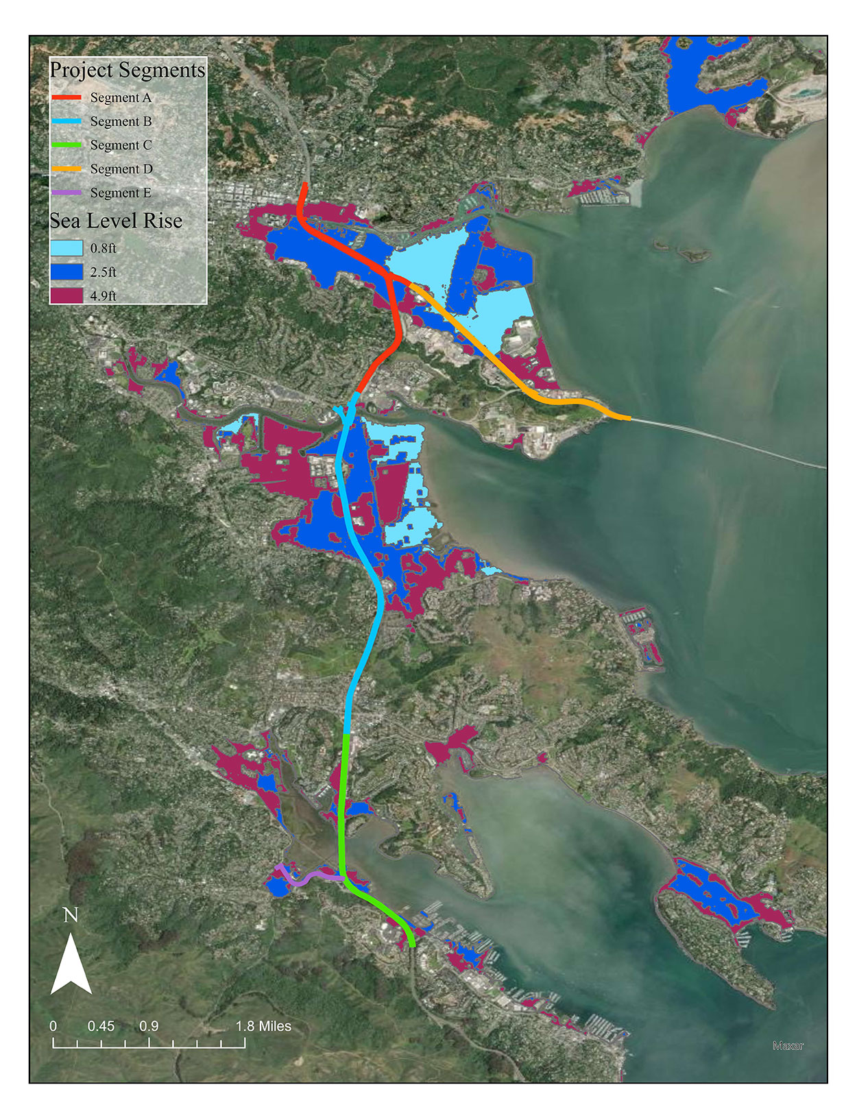
Areas at risk targeted for Caltrans community engagement around transportation assets in Marin County. Map: Caltrans
How to build these features gracefully is a question. A major highway, Ackerson says, might be a good candidate for a major upgrade that, with one fix, buys centuries of time. But for other pieces of infrastructure — especially walkways, bike paths, and sea walls — it will behoove agencies and planners to move at a more modest pace. Overdoing it with, say, a 15-foot sea wall that permanently blocks views of the water could mean losing the trust of the community.
She says a favored strategy is implementing “adaptation pathways.”
“Instead of trying to do an all-at-once project that secures us for, say, the next 300 years, we think about the pathways for getting to that level of protection,” she says, adding that a well-designed adaptation pathway also offers “an option to switch to another path before it’s too late.”
Cody J. Hedges, the Caltrans Bay Area Climate Change Adaptation Planning branch chief, said the adaptation pathway is a preferred strategy for managing a situation laden with uncertainty. The three-foot difference in projected sea level by 2100 from more extreme forecasts to more moderate ones, Hedges explains, makes it prudent to consider “what suite of solutions is available in the near-, mid-, and long term, rather than picking a date and a scenario and building to it alone.”
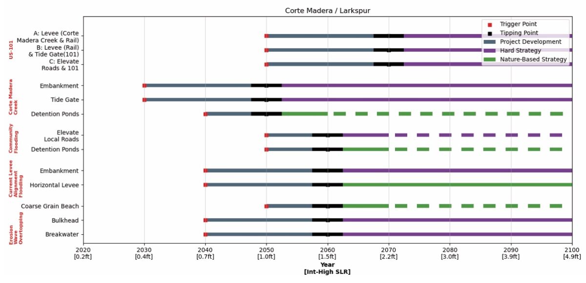
Transportation action trigger points. Each line represents a potential adaptation project, mapped over time showing different project pathways. Chart: Caltrans/Marin DOT
The multi-use path that runs across the wetlands between Sausalito and Mill Valley is one opportunity for an adaptation pathway.
To create a cost-effective buffer that protects the more vital and costly freeway infrastructure a few hundred yards farther inland, this path could be elevated just a few feet.
“And that buys you 50 years,” Ackerson says.
For communities at the edge of the rising water, there is no time to waste.
“It’s happening,” Ackerson says. “High waters are giving us glimpses of the future, showing us that it’s not a distant threat.”
MORE
- Sea Level Rise Transportation Planning Study for Marin County, 2025
- 3 Innovative Projects-Marin Sea Level Rise Study, KneeDeep, April 2025
- BayTrail Retreat in Bothin Marsh, KneeDeep, June 2021