


Who’s In Charge? What Projects Make the Cut?
Earlier this month, hundreds of leading Bay Area climate scientists, planners, academics, engineers, and activists convened at the Exploratorium on the downtown San Francisco waterfront for the third annual Bay Adapt Summit hosted by the Bay Conservation and Development Commission. One of the day’s themes across multiple panel discussions was governance of sea level rise adaptation projects, including one panel entitled: Who’s in Charge? Re-imagining what local governance looks like for Bay shoreline resilience.
It’s a question on just about everyone’s mind right now.
Earlier that same day, a group had convened to work on a case study about the management of a hypothetical major infrastructure project involving multiple agencies and jurisdictions. The first task on the docket was identifying a “project coordinator” to manage the overall effort. But no one seemed to have a perfect answer for exactly who should take the lead.
Perhaps a new joint powers authority should be formed specifically to oversee the process and bring all stakeholders together, some suggested. But a new JPA to manage every single adaptation project isn’t sustainable, either, others cautioned.
And then there’s the question of regional oversight and coordination.
“From my perspective, what’s happening right now is different jurisdictions are all competing for money, and they’re all hoping that they’re going to figure out a way to get their local projects funded,” says Mark Lubell, director of the Center for Environmental Policy and Behavior at UC Davis. “And we don’t have any regional prioritization. We’ve assembled giant lists, but out of that wish list, we haven’t sat and regionally said, ‘These are the best ones.’”
Back in 2018, Lubell authored a report called The Governance Gap: Climate Adaptation and Sea-Level Rise in the San Francisco Bay Area, where he surveyed and interviewed experts in the climate space about the region’s needs. At that time, the region was primarily at the “problem identification stage,” he says, and needed a blueprint for how to address sea level rise issues.
Other Recent Posts
Your Nine-County Guide to Bay Area Storm Prep
KneeDeep has you covered with this nine-county list of resources available in case of storm-related emergencies this winter.
Check Your Project Status: It’s All Here
The Bay Adapt Project and Funding Navigator is a first-of-its-kind, one-stop shop where everyone can find project statuses and funding ideas.
A Man Who Wears Many Hats
The leader of the San Mateo RCD’s Forest Health and Fire program says his mantra is to “be open to being wrong.”
Solano Samples Air And Finds Dirt
After helping shut down a polluting Vallejo cement plant, residents are working to expand community-led air quality monitoring across Solano County.
A Bulwark for San Francisco’s Skyscrapers?
A new joint federal and local plan maps out 13 strategies to protect 7.5 miles of San Francisco’s waterfront from sea level rise and future flooding.
Will El Niño Winter Bring Climate Chickens Home to Roost?
A dangerous combination of warm Pacific waters, Kelvin waves, king tides, and storms could disrupt life and infrastructure across the region this winter.
Inside SLR Baseball, My Summit Takeaways
A gathering of 300+ Bay Area climate leaders highlighted growing momentum on sea level rise planning — and the challenges that could slow progress.

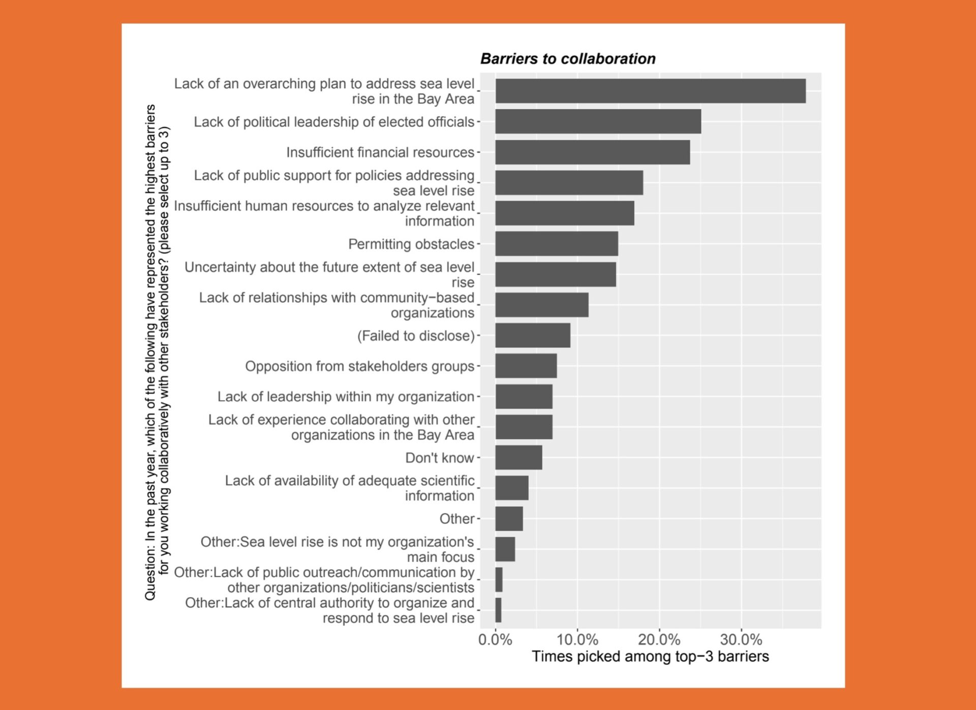
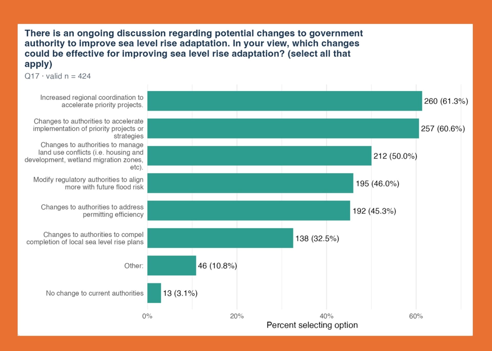
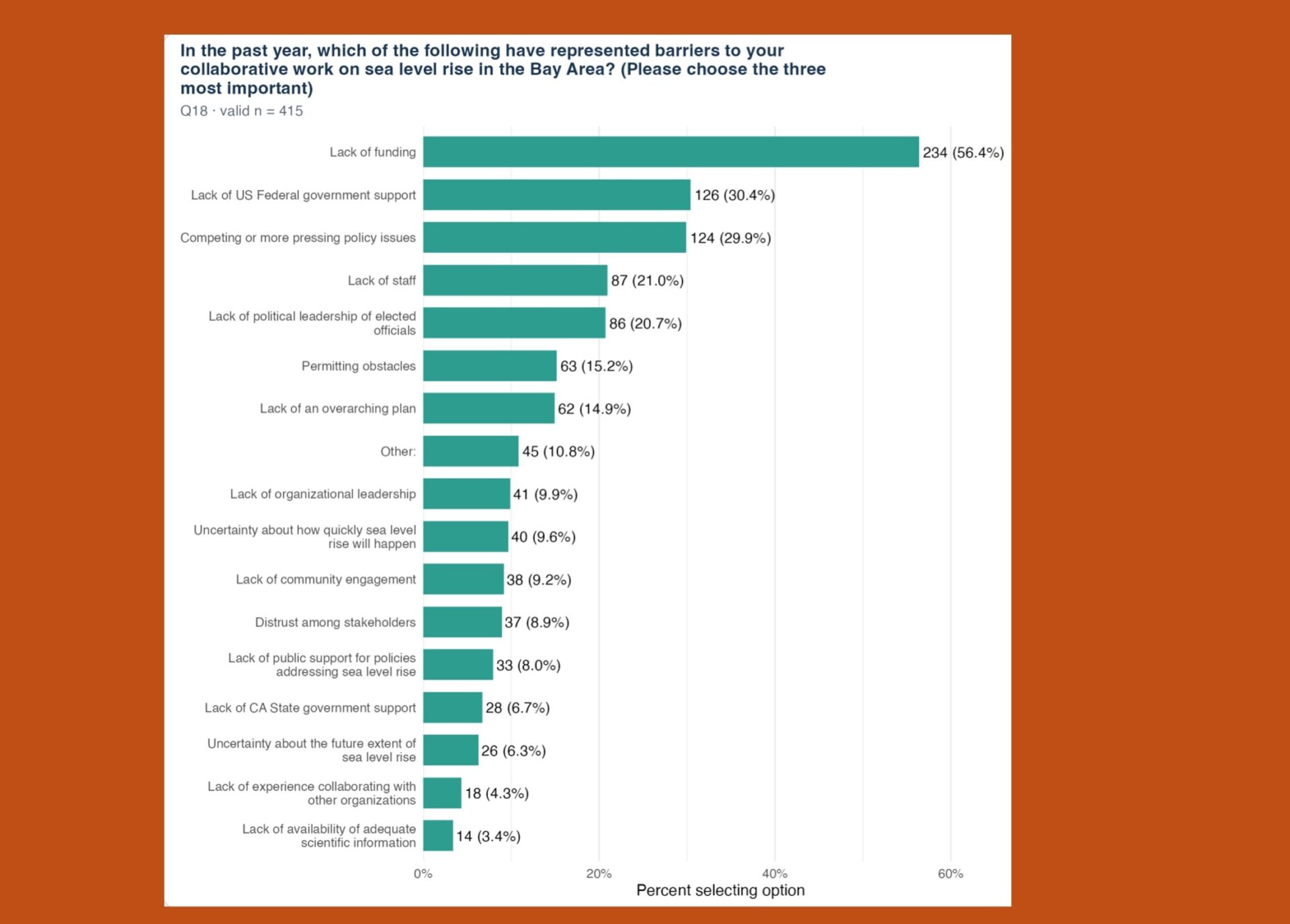
Now, eight years later, Lubell has conducted a second survey following up on his initial research to see what’s changed. The Bay Area has made what he and most of his new survey respondents describe as “incremental” or “moderate” progress. Most importantly, plans are underway and projects are in the works, with BCDC’s Regional Shoreline Adaptation Plan in place, and funding is now the biggest barrier to implementation — which is actually a good sign, according to Lubell.
“That [funding] wasn’t as much of a challenge in 2018 because we hadn’t gotten to the point of understanding what the price tag was and what the gap was,” he says. “Now, we’re at the point where we need to get the money, we need to get the projects in the ground.”
Out of more than 400 survey responses, the three most commonly identified barriers today to sea level rise adaptation were lack of funding, lack of federal government support, and competition with other policy issues. More than 60% of respondents also reported wanting to see “increased regional coordination to accelerate priority projects” and “changes to authorities to accelerate implementation of priority projects or strategies.”
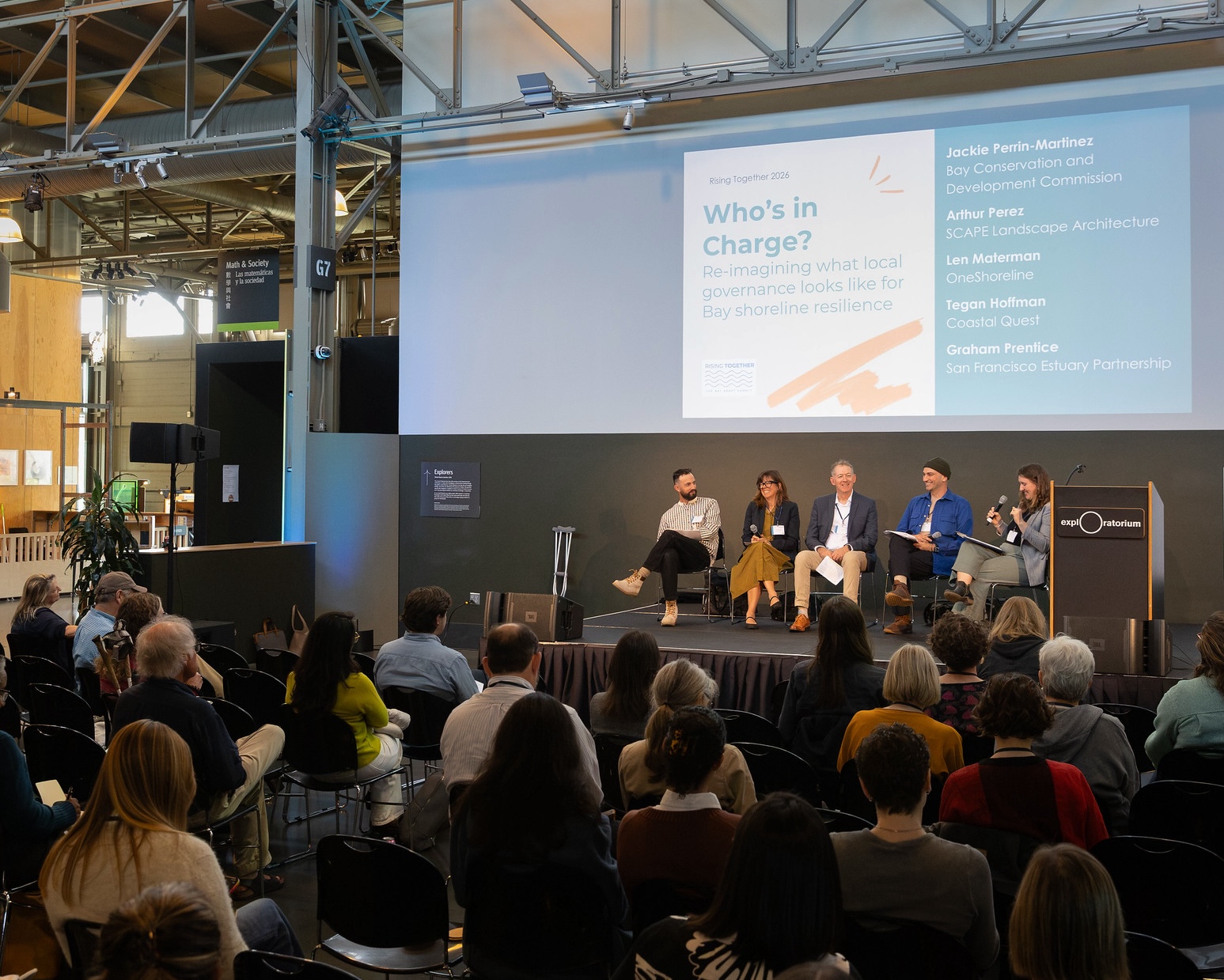
Planners, architects, and regional leaders take the stage for a panel on governance at the Rising Together summit on Monday, Nov. 9. Photo: Nicholas Lea Bruno, Courtesy BCDC
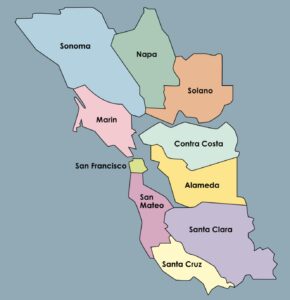
One of the key challenges unique to this region is the broad and fragmented nature of the Bay Area and the presence of nine counties and more than 100 municipalities, including several major cities instead of just one. That dynamic is “definitely an impediment for us” in terms of planning and coordination, Lubell says, as opposed to somewhere like New York having one central nucleus surrounded by suburbs.
There is not an appetite, however, to hand the keys to BCDC to directly oversee major cross-jurisdictional projects, he cautions. Instead, what could potentially work more effectively is something like a version of the San Mateo County Flood and Sea Level Rise Resiliency District, also known as OneShoreline — a special district created through state legislation passed in 2019 — for every Bay Area county. In that scenario, each OneShoreline equivalent would serve as the lead coordinator of projects in their county and interface with BCDC and state agencies to discuss priority projects, fundraising, and financing structures.
“We are making progress on sea level rise governance, but it’s been incremental. It hasn’t been transformative. A lot of people are talking about ‘transformative’ adaptation, where we’re somehow going to go from point A to point B in a very fast, nonlinear fashion. That’s not what’s happening. It’s more of an incremental progress along this adaptation cycle,” Lubell says. “There’s still a question — are we moving forward fast enough?
Top Photo: Maurice Ramirez