

Guide to Nature-Based Infrastructure Around the Bay Area
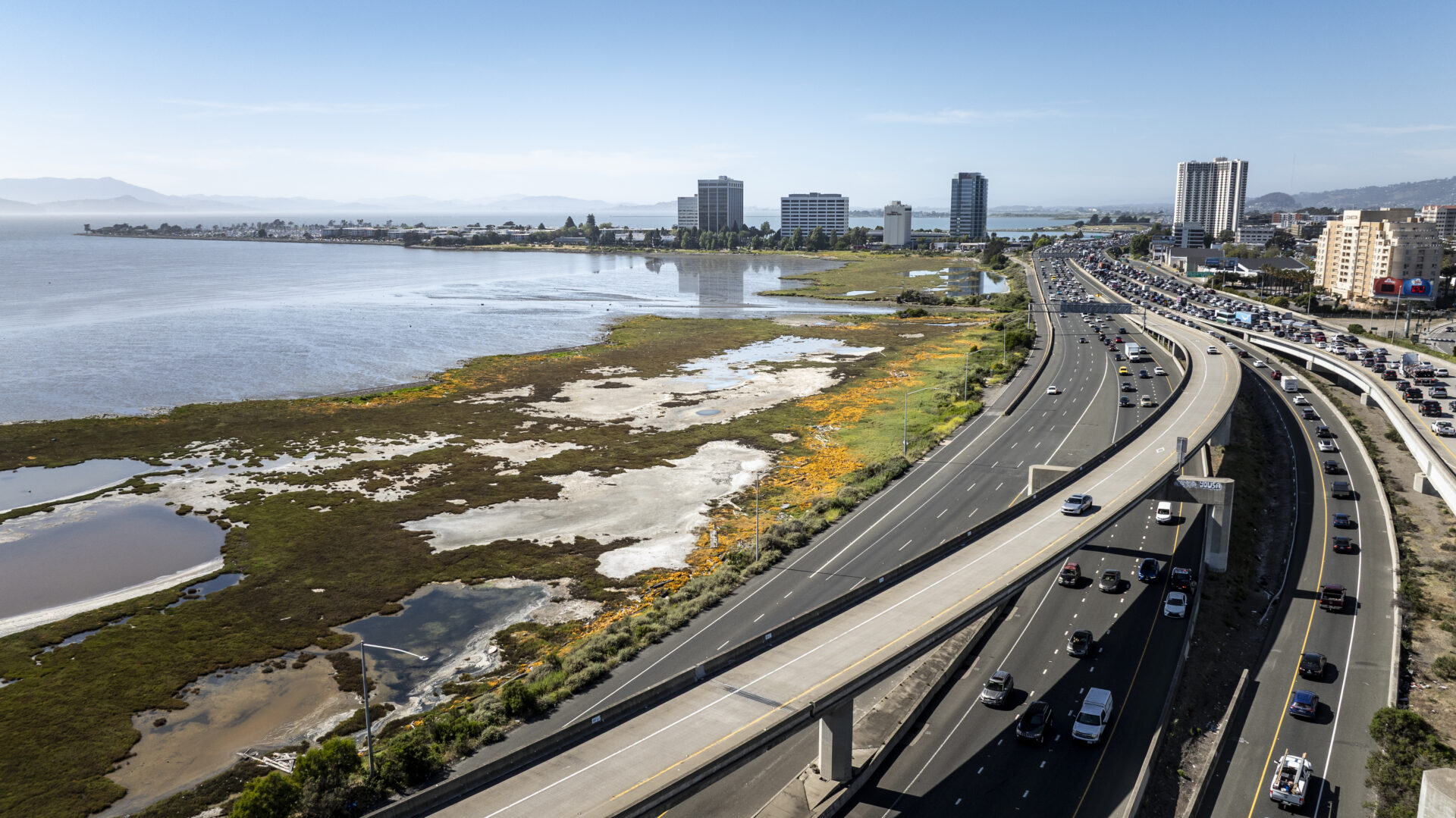
Any talk of infrastructure usually brings to mind roads, bridges, pipelines, and potholes. It suggests big, bulky, costly, and grey. Visions of storm drains and culverts, cement mixers and backhoes, seawalls and tide gates, dance before our eyes.
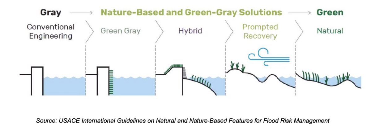
But in the San Francisco Bay Area, as the region confronts rising sea levels and wetter storms, this infrastructure is being reinvented. Engineers and scientists are using different materials and different designs to make grey infrastructure bluer and greener. To soften the hard edges with plants and more absorbent and moveable materials. To use oyster reefs and gravel beaches and humpbacked levees to make our shores more resilient to flooding.
This “nature-based” infrastructure isn’t a new thing, but it’s trending. It focuses on working with nature, not against it. “The real value of nature-based solutions is not that they replace traditional infrastructure, but that they make it work better, last longer, and provide benefits concrete never will,” says San Francisco Estuary Institute environmental scientist Jeremy Lowe.
TECHNICALLY…
….according to the American Society of Engineers, “river floodplains, setback levees, forested water supply watersheds, freshwater and coastal wetlands, living shorelines, dunes and beach systems, living breakwaters and reefs, and other features can function as natural and nature-based infrastructure. Nature-based solutions can also refer to different techniques at the watershed or landscape scale that build interconnected systems of natural areas and open space; it can be used in the urban environment, such as in stormwater runoff management or for urban heat island mitigation, and in coastal interventions to stabilize the shoreline, reduce erosion, and buffer the coast from storm impacts.”
Resources for engineers exploring these options for the first time include standards for nature-based design or guidelines for engineering with nature (USCOE). Don’t forget to think about the importance of sediment to increase your project elevation in the face of rising sea levels, as well as other green materials.
Art: USACE
Source: SFEI and KDT
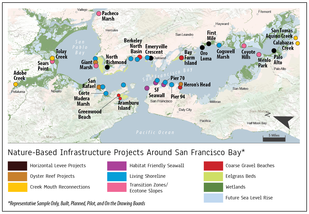
If you want to get an idea of the variety of resilience projects around the Bay, the region maintains several databases (BCDC Inventory 2050, Plan Bay Area 2050+, and the EcoAtlas).
In this love-fest for nature-based infrastructure, however, there has always been a key warning: one size does not fit all. Local conditions change everything. Projects must take into account the local microtopography and microclimate, not to mention the needs and vulnerabilities of the adjacent communities and ecosystems. That’s why there are as many project types as there are spots that need them.
The following offers a representative guide of local projects.
Construction was completed on Palo Alto's horizontal levee in fall 2026. Photo: Heidi Nutters
Horizontal Levees
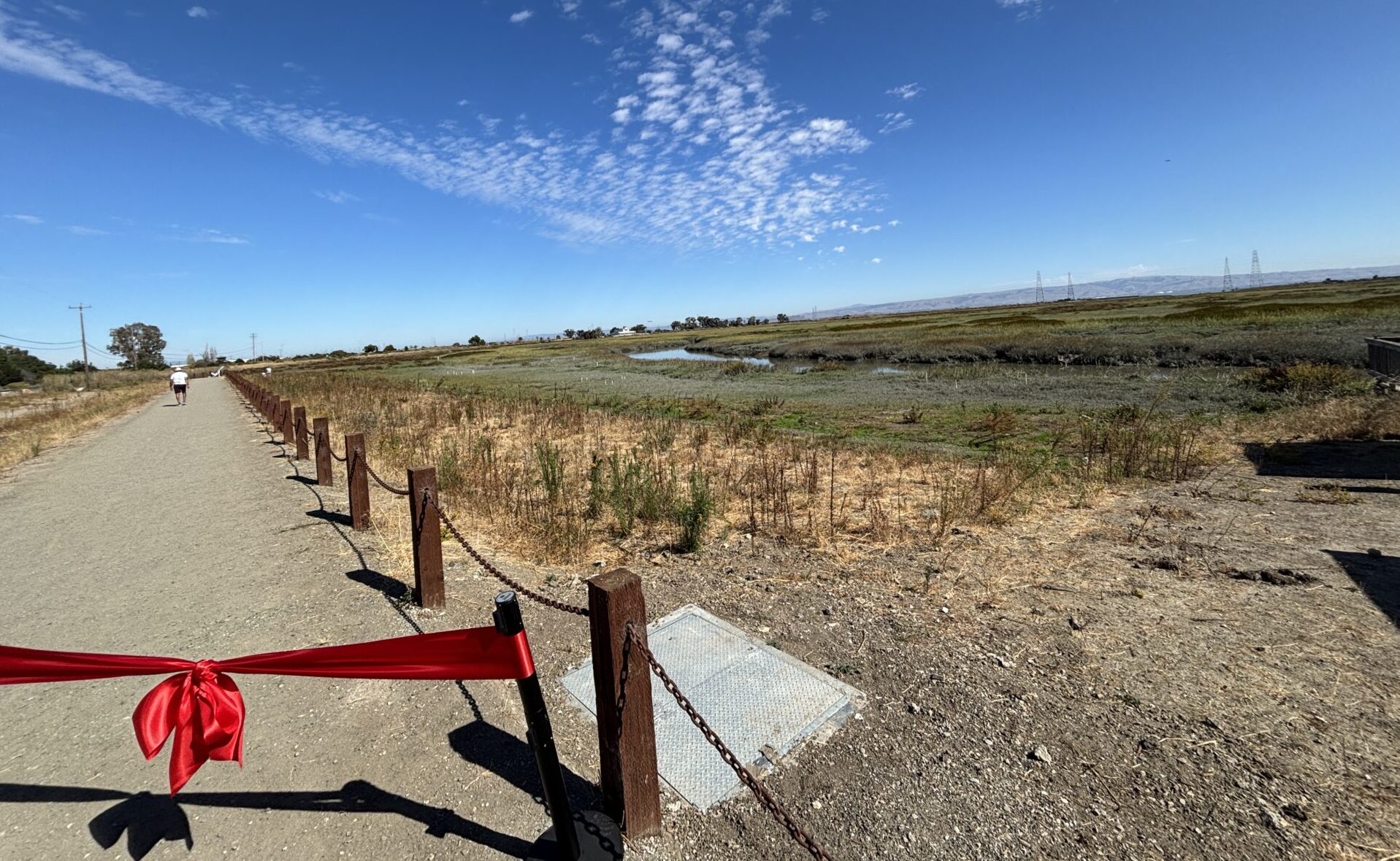
A horizontal levee is a wedge-shaped levee, planted on one side with hardy native species and irrigated with wastewater. As a “levee,” it’s still basically a wall between the shore and the water designed to prevent flooding, but the resemblance to a more conventional riprapped levee or dirt berm stops there. Rather than a mound, it’s a wedge; rather than hard, it’s soft; rather than bare, or covered in broken rock, it’s vegetated. Often they are sited just inland of an older, weaker levee.
Horizontal levees — also variously known also as ecotone slopes or habitat levees (see next section) — are fast becoming a popular transitional object in the fight to adapt to a rising Bay. Some will help sewage plants better “polish” and remove nutrients from their wastewater; some will offer flood protection to critical infrastructure; some will provide high ground for marsh mice and birds to escape high tides; and some will grow native species favored by Indigenous tribes for cultural use. Many will try to do more than one of these things, all at once.
As of 2022, there were already half a dozen of different sizes and shapes planned around the Bay Area. As of 2026, two have actually been built (Palo Alto and a pilot at Oro Loma). Other projects include: The First Mile-Hayward; North Richmond-West Contra Costa Sanitary District; Emeryville Crescent; and more (see map above).
TECHNICALLY…
….horizontal or “living” levees are planted slopes that rise gradually from the intertidal zone to dry upland. The combination of the slope and the plants work together to slow waves that otherwise crash unimpeded on the current earth, rock, and concrete levees now protecting the San Francisco bayshore, many of which are steeper-sloped.
Recent science suggests that placing these wider, more gently-sloped levees in front of existing levees can both reduce flooding and extend the life of the older levee. The main drawback is the additional cost of larger footprints: more materials and larger land purchases. But the costs of levee failure can be several orders of magnitude greater.
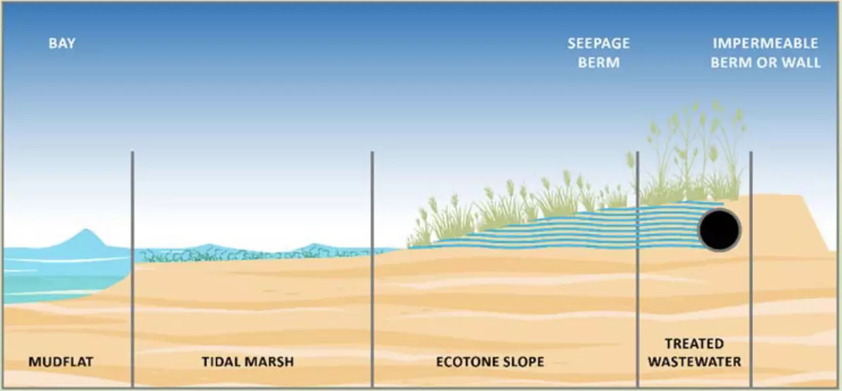
Historically, “habitat levee,” “ecotone levee,” and “habitat transition zone levee” are the more general terms, and “horizontal levee” is the only one that has been specifically attached to designs including a subsurface wastewater treatment component (drain lines, a special mix of gravel and soil materials, and plant roots help remove nutrients from the wastewater). None of these terms have a regulatory basis.
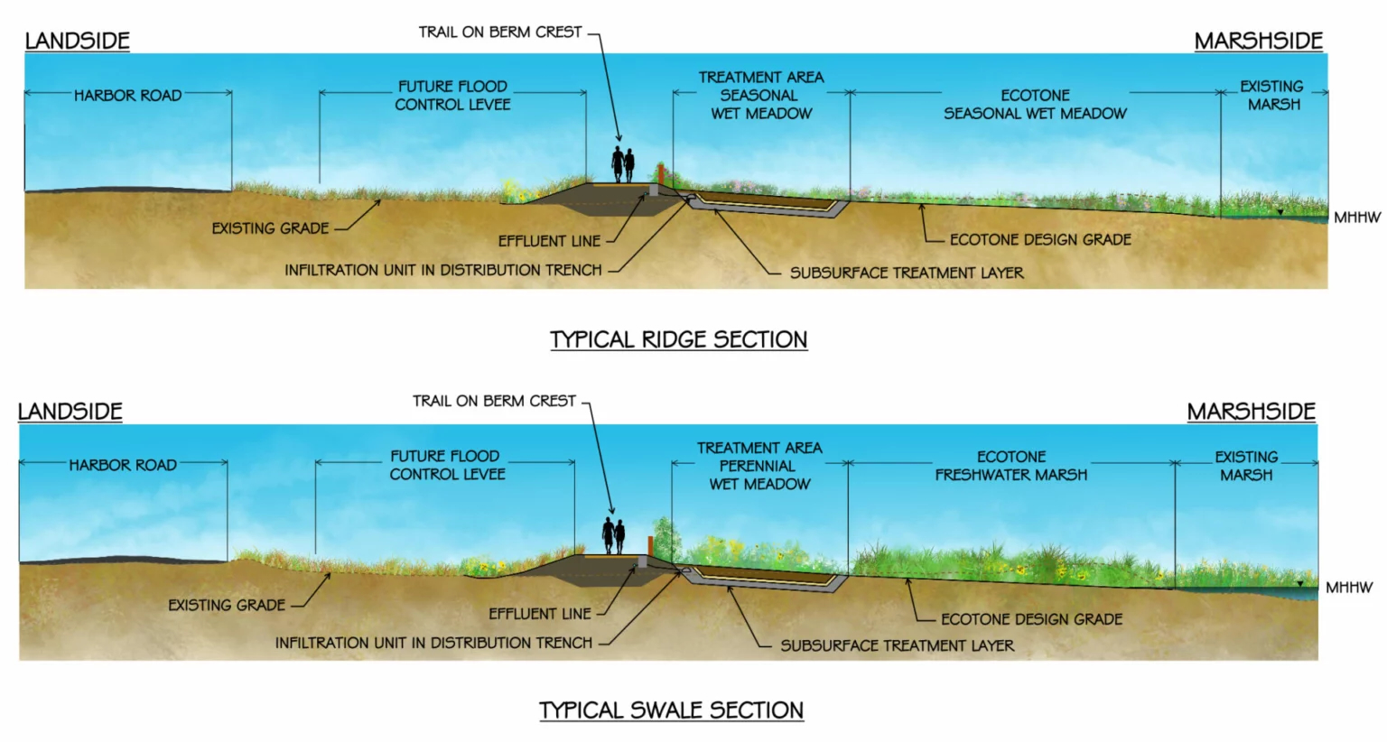
Palo Alto horizontal levee design. Art: ESA
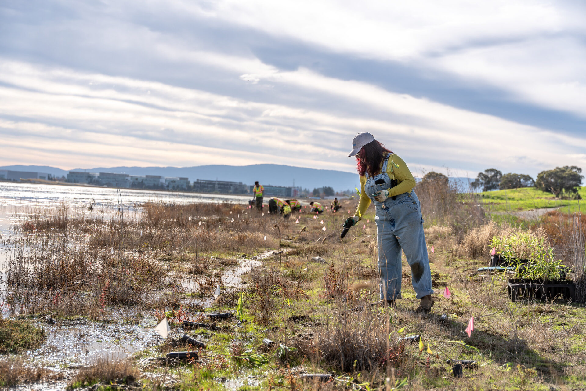
Habitat transition zone at Ravenswood. Photo: Save the Bay
Ecotones & Transition Zones
An ecotone is a transition zone between two ecosystems. In the Bay region, shoreline managers most often use the term to describe the slope or border zone between terrestrial and aquatic systems, like tidal wetlands and the Bay. With sea level rise, more attention is being paid to bulking up and widening these zones, and planting them with hardy native species, so they can better serve as on-ramps for wetland or habitat to “migrate” inland. But ecotones are not just being deployed in the uplands around wetlands. They are also creeping into designs for managed retreat of parks, trails, beaches, and other shoreline features away from the water. Imagine something like a levee but not so crisp, blending into the existing landscape rather than serving as a divider.
Almost every new wetland restoration project in the Bay Area now includes elements called transition zones. Examples can be found in Menlo Park, the Coyote Hills, Pacheco Marsh in Walnut Creek, and Point Pinole’s Giant Marsh (see map above). The ongoing restoration of the South Bay Salt Ponds includes numerous ecotone levees, Pond A8, Pond A2W, Ponds A12, A13, and A18, and Pond R4, for example.
TECHNICALLY…
…an ecotone is the border zone between ecological systems, the edges and physical boundaries where systems overlap and can form new and different biological communities. As such, it can also be a line of stress on these systems: regions where species are at the limit of their tolerance for certain environmental conditions.
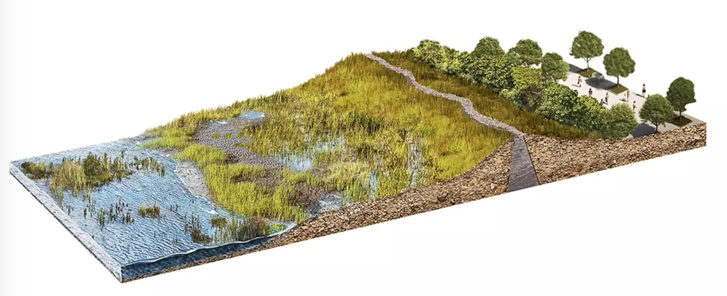
Art: Punto Aparte
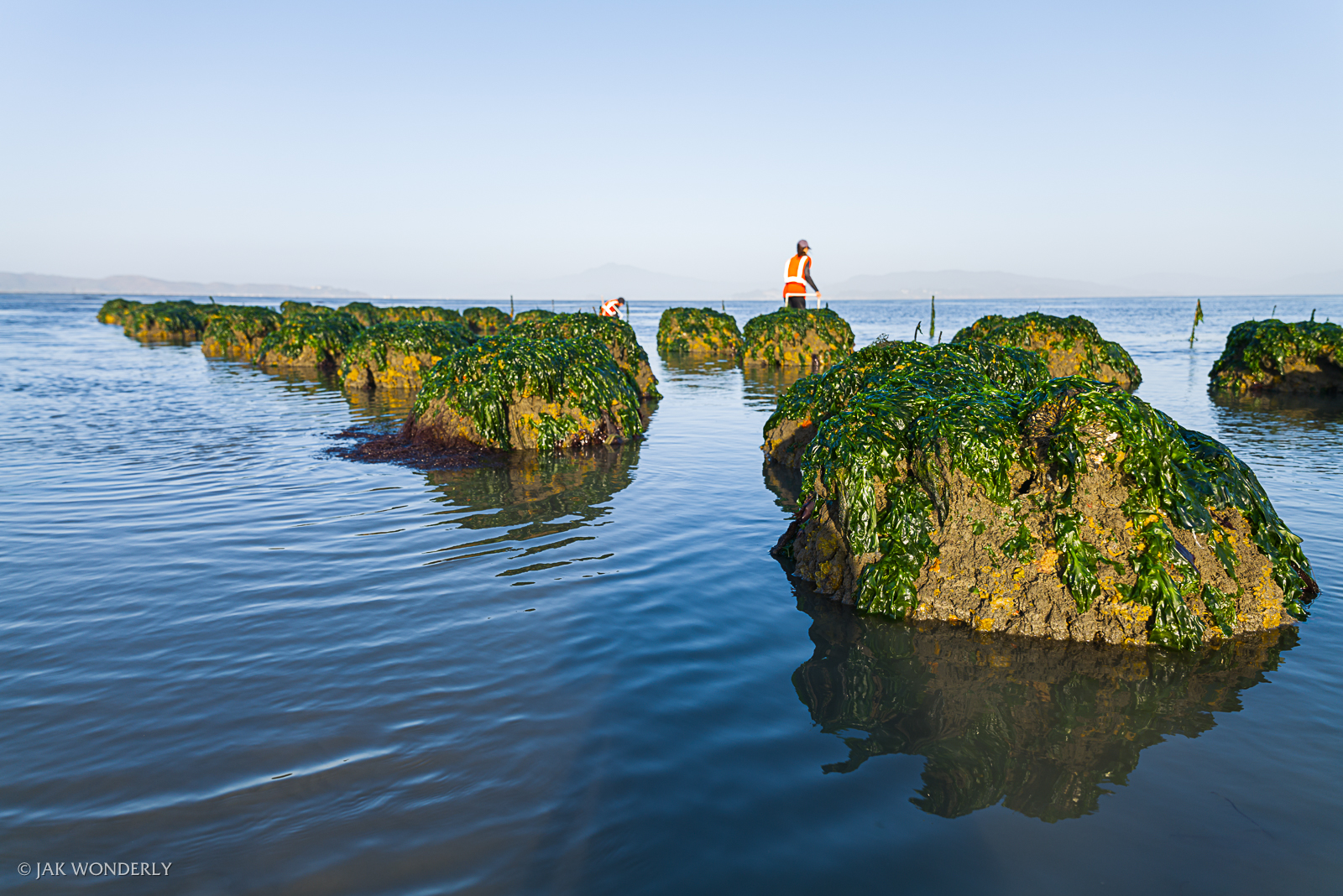
Oyster reef balls at Giant Marsh. Photo: Jak Wonderly
Oyster Reefs
Oysters are often called ecosystem engineers: once they attach themselves to rocks or other hard structures on our shores, dozens of other species join them. But the soft muddy shallows of San Francisco Bay don’t offer much for them to attach to, so local scientists have been creating structures in the shape of blocks or balls and placing them in the subtidal zone. These structures are like a miniature apartment complex for marine life, and are made of local “baycrete,” a mix of concrete, native sand, and gravel, and crushed oyster shell to attract, or “recruit,” oyster larvae.
In San Francisco Bay, there have been three major experiments with creating oyster reefs in the shallows to date: San Rafael, Giant Marsh, and Heron’s Head (see map above). Many other projects seek to foster wild oysters in one way or another, but these three offer more direct examples of local “nature-based engineering.” Numerous other oyster restoration efforts are underway between San Diego and Seattle.
TECHNICALLY…
…the Olympia oyster, the only oyster native to the West Coast, doesn’t build big reef structures like its Atlantic cousins. In the right conditions, as in some estuaries in Southern California, Olympia oysters naturally form dense clusters like low, lumpy speed bumps on the seafloor. In San Francisco Bay, however, they need surfaces to attach to, hence the experimental reef blocks and balls.
Monitoring of the first experimental San Francisco Bay projects found that: more than 3 million native oysters initially settled on the reefs, with some loss over time due to changing environmental conditions, as well as competition, predation, and recruitment fluctuations; most oysters settled on vertical, north-facing elements at lower tidal elevations, likely due to reduced heat stress; shell bags performed better than the four other structures tested, possibly due to more surface area; the lowest recruitment occurred on the layer cake and oyster block structures; and the structures did not subside substantially in bay mud. Five years of monitoring of the Giant Marsh project yielded many more specifics.
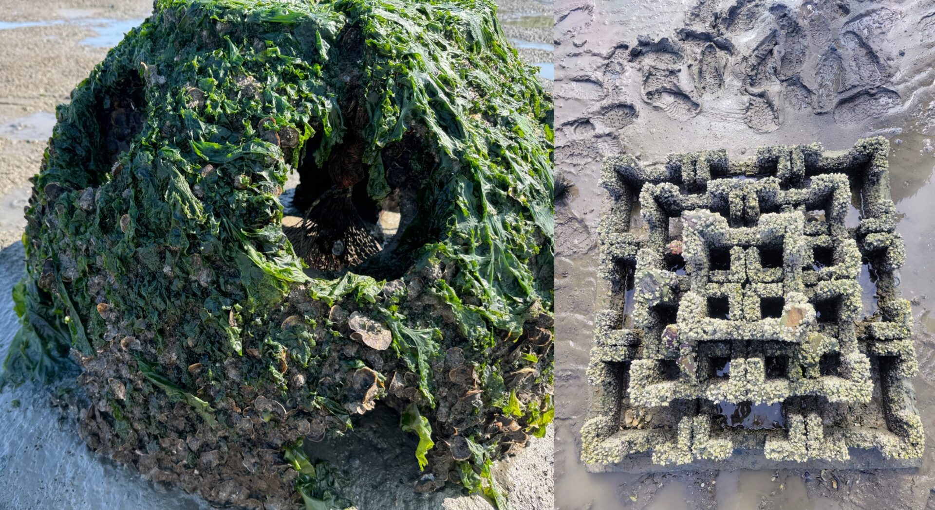
Photos: Chela Zabin (R); Sony Bennett-Brandt (L)
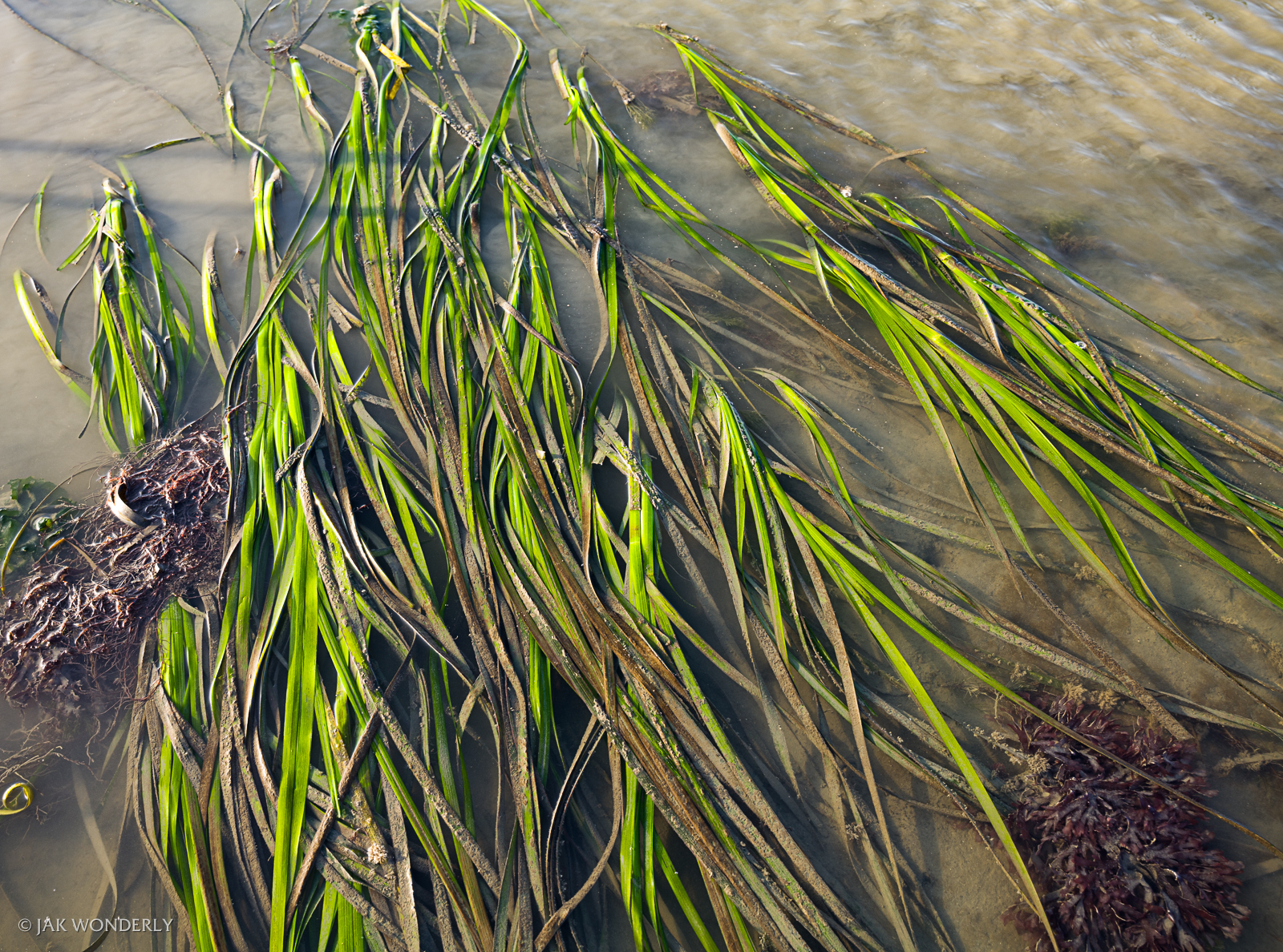
Eelgrass planted in San Francisco Bay. Photo: Jak Wonderly
Eelgrass Beds
Eelgrass is subtidal seagrass (Zostera marina) that grows in shallow water meadows. It stabilizes sediment with its deep, dense root systems, filters nutrients and pollutants, and provides habitat for a whole cast of juvenile fish and invertebrates. It grows naturally in San Francisco Bay, but recently shoreline managers have been planting eelgrass near oyster reefs. In association with each other and as part of nature-based infrastructure, these two ecosystem engineers produce more ecological benefits than they do in isolation. Eelgrass can also buffer wave energy, absorbing the force of waves with the back-and-forth sway of its long, skinny leaves.
Currently, there are about 3,000-4,000 acres of eelgrass meadows on the bottom of San Francisco Bay; restoration projects in the last decade added about 5-10 acres per year. Major projects include: Giant Marsh, Middle Harbor in the Port of Oakland, and Richardson Bay in Marin County (2023 eelgrass restoration plan), among others (see map above).
TECHNICALLY…
….a lot of research went into how best to plant eelgrass in the shifting mud beneath the Bay and get it to stay in place. Planting methods ranged from scattering seeds to attaching a shoot of eelgrass to a bamboo stick and sticking it in the mud to keep it there. Scientists at the EOS center (formerly SF State) spearheaded a lot of research, while environmental contractor ESA has learned a few things, too. More recently, researchers created a model of where the most suitable areas for eelgrass restoration are in the Bay.
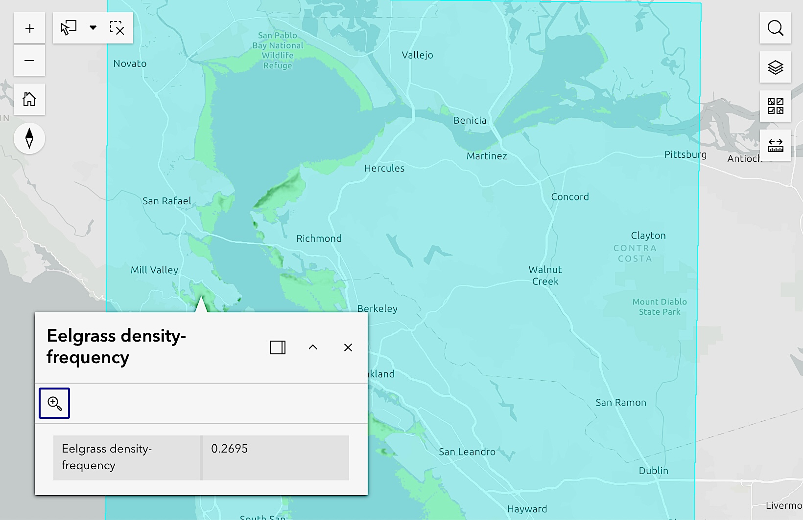
Sample from model.
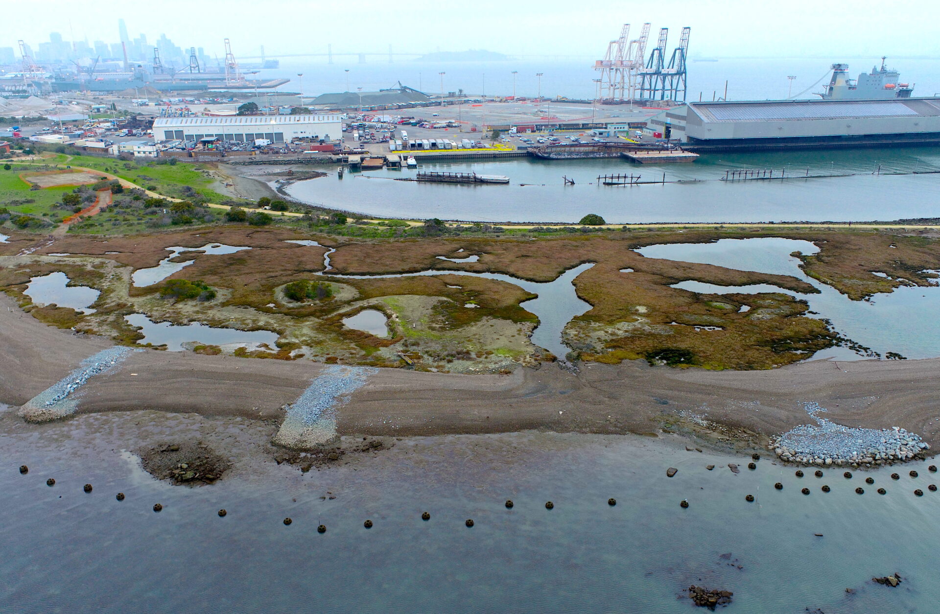
Heron’s Head beach and peninsulas. Photo: ESA
Coarse Gravel Beaches
Beaches — the small and gravelly kind, rather than the fine, sandy, and expansive kind — are fast becoming an important component of nature-based infrastructure around the Bay. Adding pockets and peninsulas (also called tombolos) of coarse gravel around eroding or drowning wetlands can help buffer them from waves. Gravel pockets or beaches can be positioned so that tides and prevailing waves or currents move the gravel to places where it’s needed to bulk up eroding edges, or to deflect waves from vulnerable shores. Traditional “groins” or hard infrastructure can be used to guide where the sediment goes.
Examples of built Bay beaches include Heron’s Head in San Francisco, Arambaru Island in Marin, and Bay Farm Island in Alameda (see map above). Many other projects are in the design, planning, or construction phase, adding shores that can either shape shift or stay put as sea levels rise, storm surge intensifies, and erosion worsens.
TECHNICALLY…
…beaches are nothing new to marsh ecosystems, there just aren’t that many left around the Estuary’s shore due to development and levee-building. To bring them back, a key ingredient is the material, ranging in size from grains and specks to gravel and cobbles. Sand and other beach-building materials are more precious than ever because they comprise the bulk of what’s needed to elevate our drowning shores on both ocean and bay coasts.
The difference between ocean and estuarine beaches is where the source material comes from. On ocean beaches, waves and currents pick up and move the sand: they usually deposit sediment, but bigger waves, stronger El Niños, and sea level rise mean that California’s beaches are at risk of eroding away. Around the Bay, the sediment for beach building has to come from creek and river mouths, or be imported from the beneficial reuse of dredged material, quarries, sandmining, or development excavation. For buffering beach projects, scientists and engineers prefer a coarser, heavier material more likely to stay put. Beaches are just one component of nature-based infrastructure that can breathe new life into eroding shores.
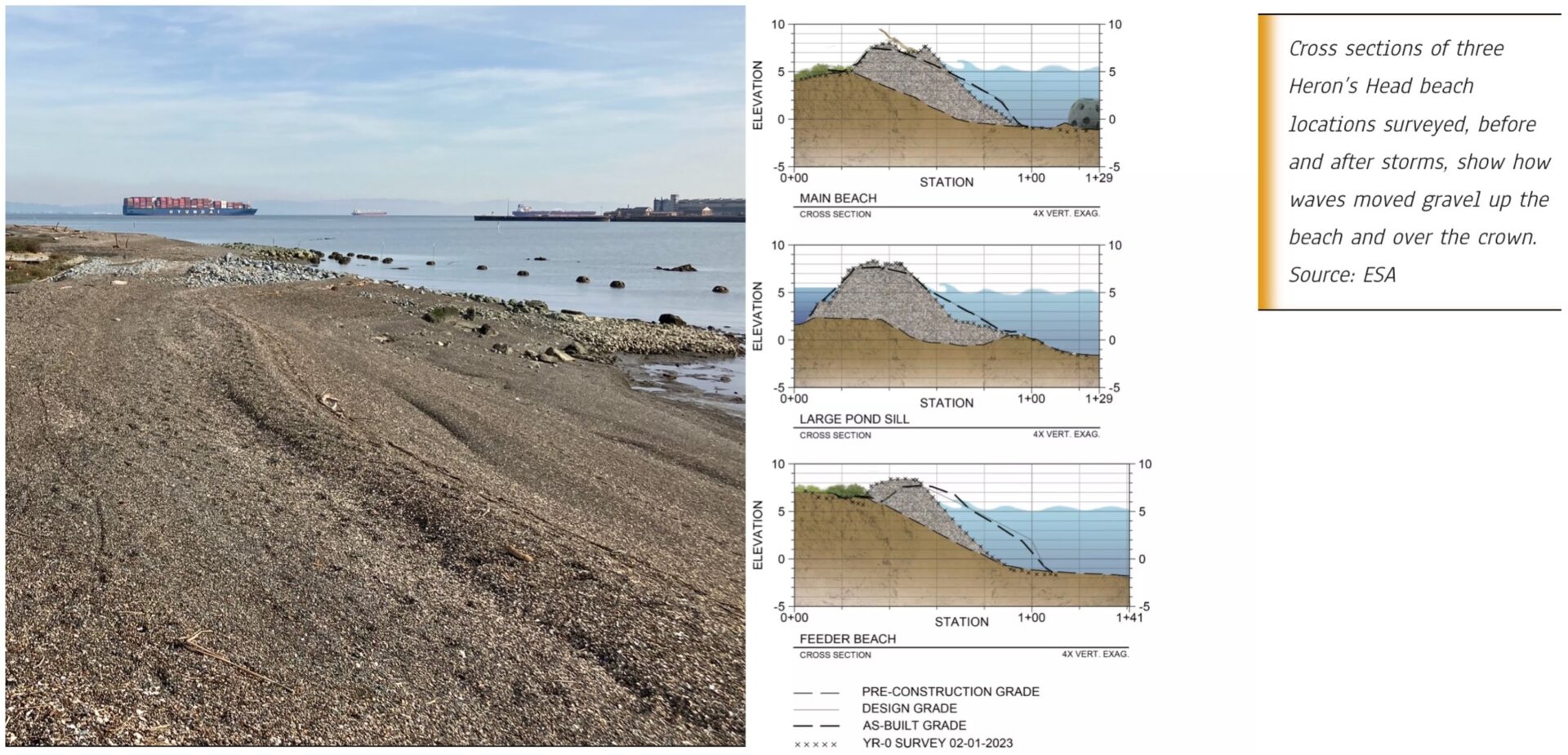
Gravel performance before and after storms. Source: ESA
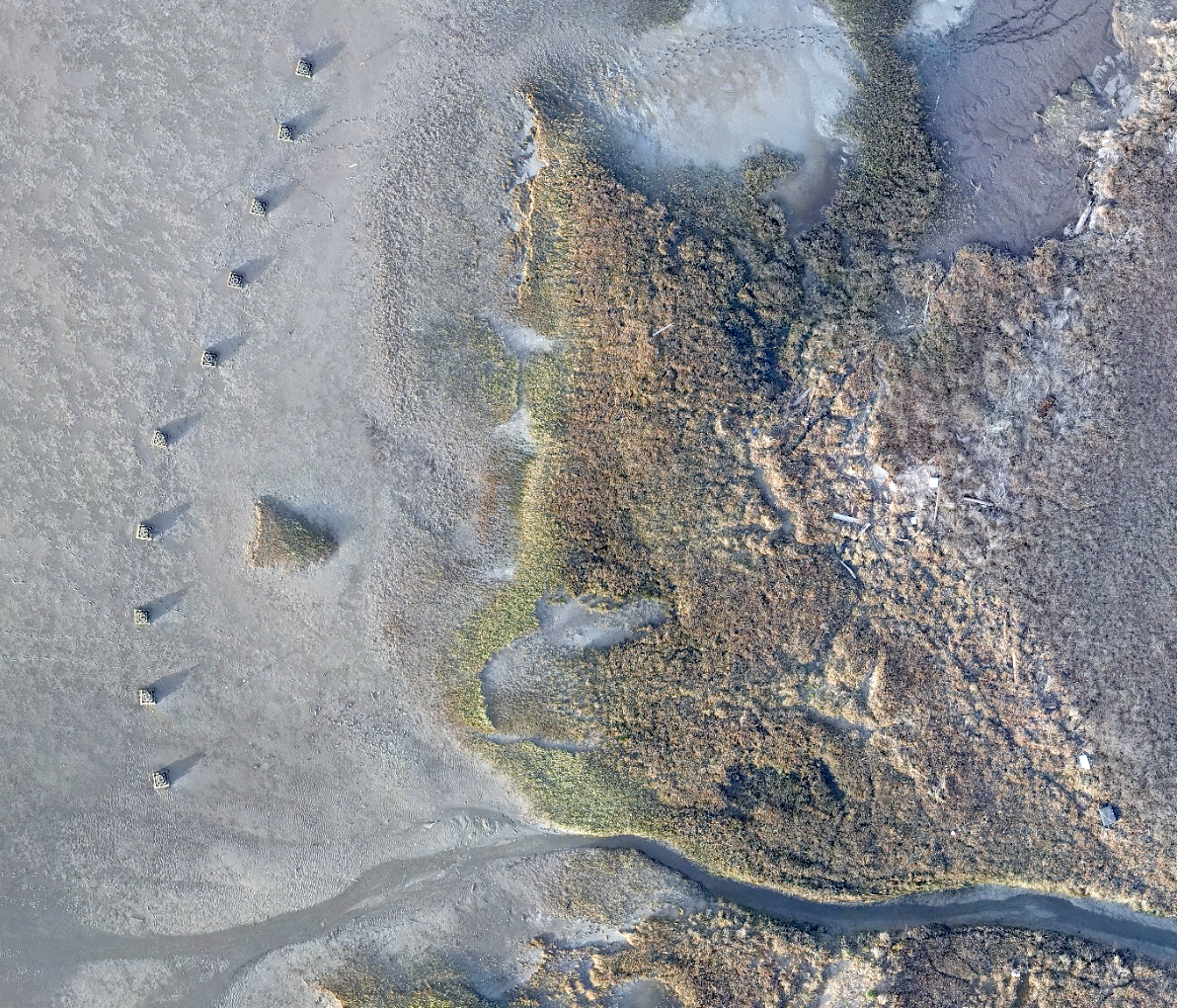
Nearshore oyster reef at Giant Marsh. Photo: ESA
Living Shorelines
Living shorelines protect the coast with organic materials — plants, sand, stone, shell — strategically placed to attenuate wave energy, keep sediment on the beach, and filter runoff moving from land to sea. “Living shoreline” is a sort of umbrella term that can include many of the other elements in this guide, often combined — eelgrass and oyster beds are both recurring cast members in living shoreline projects.
Unlike seawalls or levees, living shorelines can move. As seas rise, oysters, eelgrass, and other biological elements have the potential to migrate inland (as long as there’s space), mobile coastal protection infrastructure that doesn’t have to be demolished and rebuilt when the tide line shifts.
The strategic placement of stone, sand fill, and other structural materials can all play a role in living shoreline projects to create “hybrids of traditional shoreline armoring and the softer approaches to shore protection,” as described by Restore America’s Estuaries.
The Bay region now hosts a variety of living shoreline projects, including Giant Marsh near Point Pinole in the East Bay, as mentioned above. There’s a plan to regionally advance living shorelines projects now underway that aims to design and permit 10 more projects (see map above and inside sidebar).
TECHNICALLY…
… Giant Marsh offers the region’s most developed and mature example of a living shoreline as a mosaic of plantings, oyster reef structures, and placement experiments extending from Bay shallows all the way to the edge of the uplands, encompassing the tidal marshes in between. Seven habitat treatments with a footprint of about two acres are scattered across this shore zone habitat gradient over an area totaling 350 acres. Seven years after building the project and five years of monitoring later, the 17 partners that undertook the project have some very specific results about the success of this living infrastructure.
Based on these results and concerns over other eroding shores and shrinking habitats, the Regionally Avancing Living Shorelines project (RALS) is exploring 10 more locations. The effort has deployed three different nonprofits (Marin Audubon Society, Ducks Unlimited, and Golden Gate Bird Alliance) and three different design teams (ESA, Moffatt Nichol, and GHD) to design new projects in three parts of the Bay (Marin, East Bay, and San Francisco).
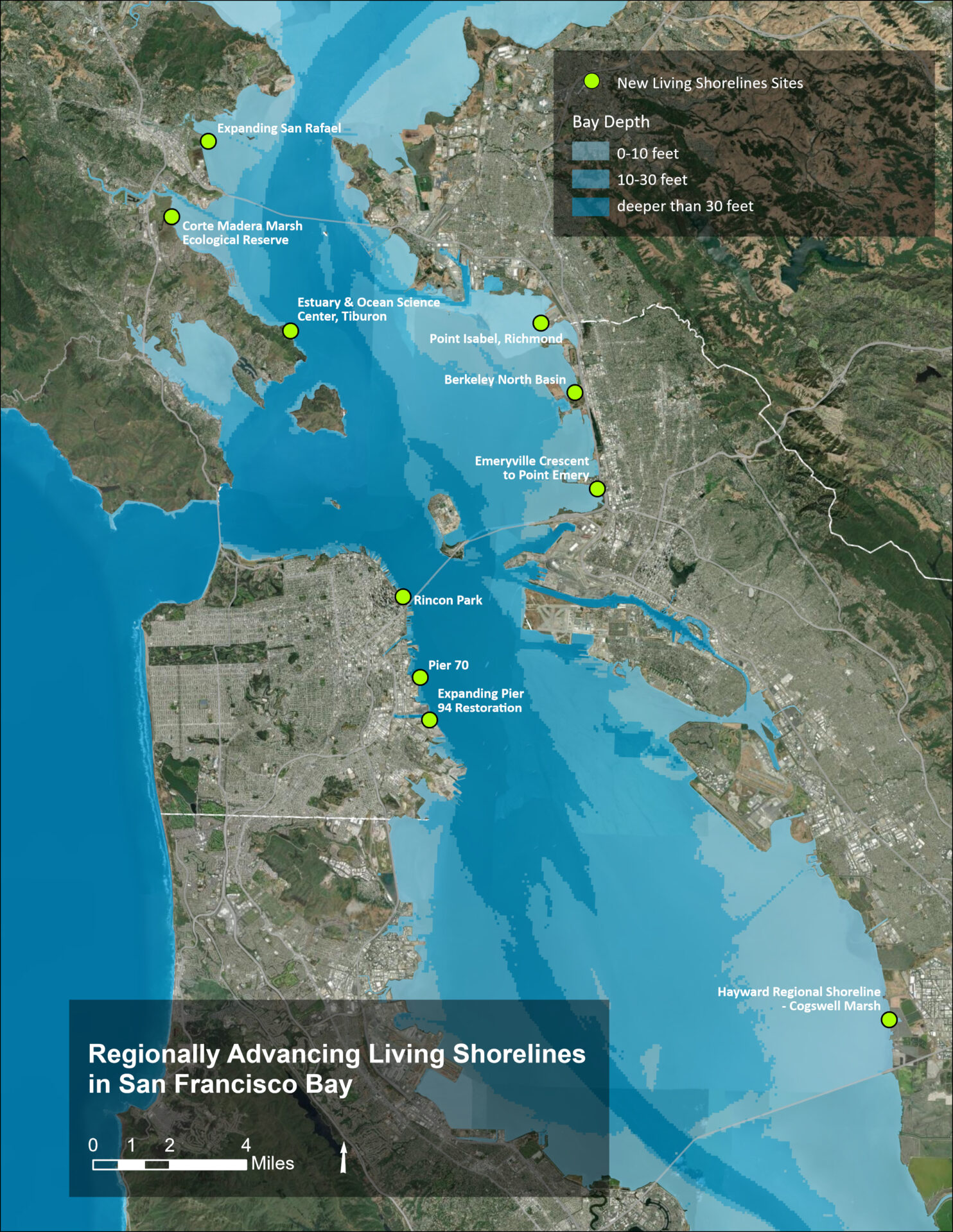
Map of 10 sites targeted for potential regional living shorelines projects. Map: State Coastal Conservancy
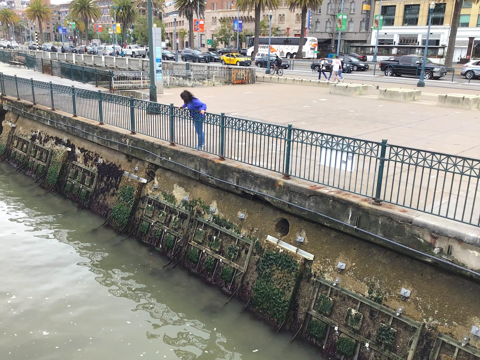
Experimental textured tiles on San Francisco seawall. Photo: Ariel R Okamoto
Living Seawalls
The smooth concrete of most seawalls offers little habitat for marine life, but it doesn’t have to be that way. Texturing seawalls to give native species a slimy foothold is a growing priority worldwide: both Australia’s Sydney Harbor and Seattle have species-facing seawalls in the water already.
In San Francisco, those working to protect the waterfront have been experimenting with adding grooved, ribbed, and dimpled pieces of the seawall so they can attract and support herring, oysters, rockweed, hermit crabs, and other native species of the Bay’s natural rocky shore. In an ongoing experiment, the Port of San Francisco deployed more than 288 experimental tiles ranging in size from large to small, and from bumpy to smooth. Not only do these tiles have texture, an “admixture” of bumps, ridges, and pockets, but also a special chemical signature marine species find attractive. They were molded and cast by an international company called Econcrete. The Port is also exploring the idea of a gray-green, rocky-intertidal engineered bluff as one option for creating more vertical habitats along San Francisco’s aging seawall, as well as other nature-based waterfront resilience options.
TECHNICALLY…
…While results vary from place to place along the world’s coasts, science suggests that if you add more surface complexity to seawall surfaces, you get more species. In San Francisco’s experiment, scientists and port engineers hung the tiles from the waterfront at three different locations and tidal elevations in 2022, and have been monitoring the bio-friendly surfaces ever since. Early results confirmed at least one very important outcome: most of the species growing on, hiding in, or attached to the tiles were native.
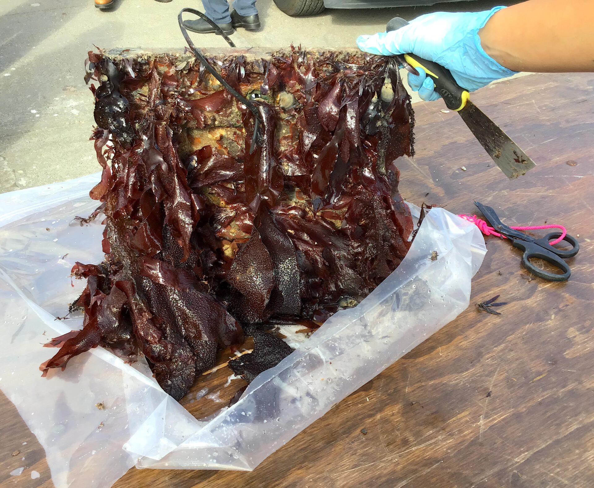
San Francisco is exploring a variety of nature-based approaches to making it’s highly urbanized shore and seawall more resilient.
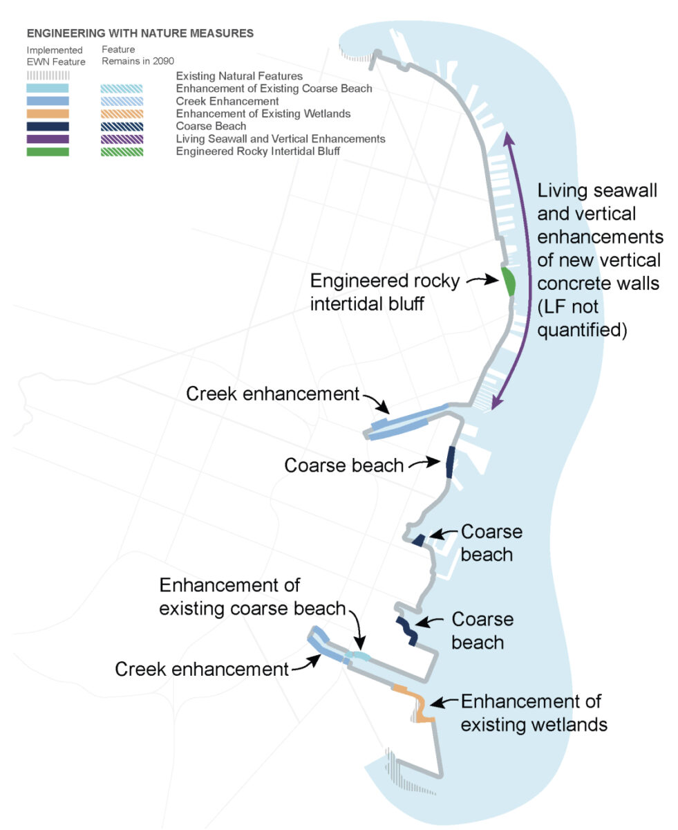
Recommended nature-based options for San Francisco seawall from the July 2026 coastal flood study. Art: USACE
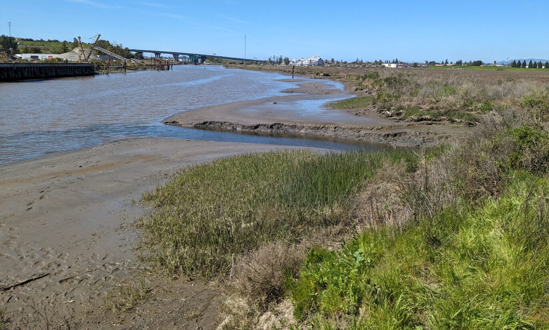
Mouth of Adobe Creek flowing into Petaluma River. Photo: Scott Dusterhoff, SFEI
Creek & Wetland Links
Humans building new infrastructure with natural processes in mind often consider creating links across existing wetlands, rivers, creeks, upland habitats, and corridors to open space. A more connected ecosystem is a healthier one, with more bandwidth to shift, swell, and contract with rising tides and variable water years.
In the Bay region, one of our most critical flood protection buffers, for example, is tidal wetlands. An SFEI report found that the Bay Area has 53,700 acres of tidal wetlands as of 2020, an increase of 16% since 2009. Regular tracking of the region’s wetland extent and health is now undertaken by a collaborative monitoring program.
In addition, more than a hundred creeks drain into the Bay, bringing important building blocks for elevation rise, such as eroded sediment and fresh water, to the Estuary. They in turn also serve as natural and engineered flood control channels, and water storage and conveyance systems. If designed, engineered, or restored with current precipitation extremes and natural processes in mind, creeks can become powerful pieces of nature-based infrastructure.
Wetland and creek restoration projects are nothing new to the region, and recent climate forward examples include the shoreline at Mountain View and shallow water sediment placement to support Eden Landing. Creek projects include: Colgan Creek near Santa Rosa, Adobe Creek and Tolay Creek in the North Bay, Rheem Creek and Pacheco Marsh in the East Bay, and Calabazas and San Tomas Aquino Creeks in the South Bay (see map above).
TECHNICALLY…
…there are 12 types of creeks in the Bay Area, according to a recent classification by UC Davis. Some are lined with concrete to carry storm flows, and others have been patched or propped up or culverted here and there as humans try to moderate the effects of these waterways on their homes, businesses, roads, and bridges.
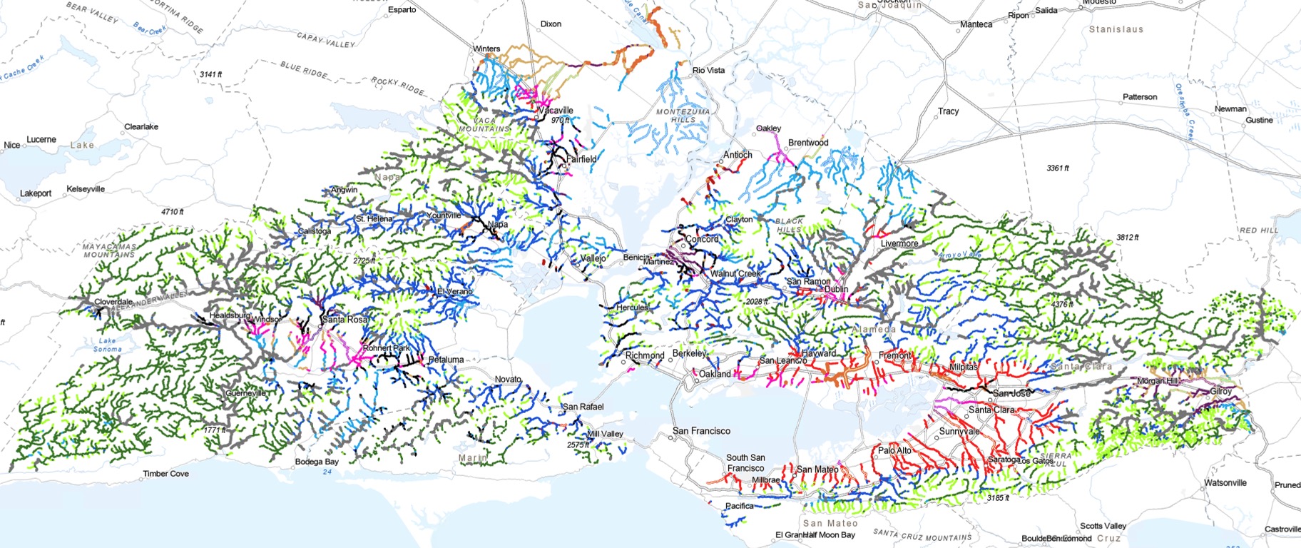
Bay Area creeks classification. Map: UC Davis
Daylighting bayshore portions of creeks and reconnecting them to the Bay has the potential to rebuild natural processes feeding critical sediment to drowning tidal flats and baylands.
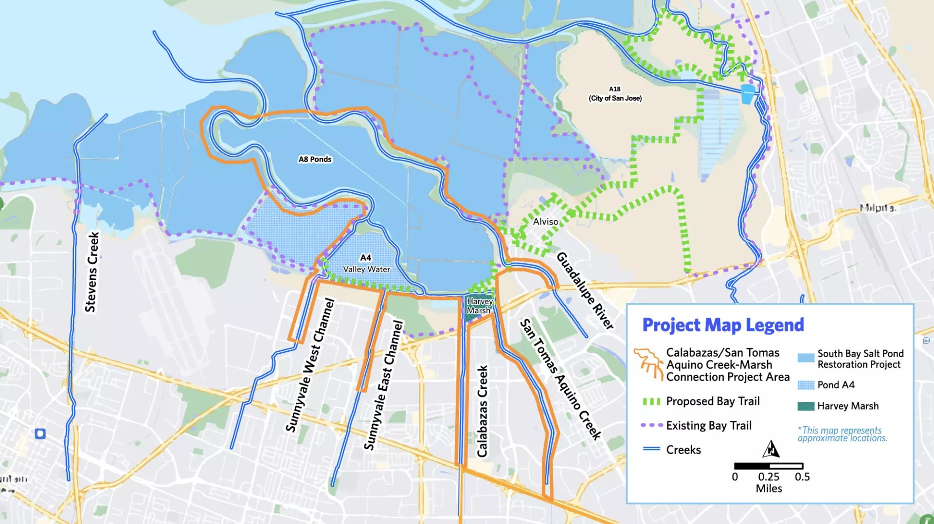
Valley Water’s plan to reconnect channelized creeks to the South Bay, and deliver more sediment to outboard tidal flats and wetlands. Map: Valley Water
Nature-Based Mentality
Every project in this guide is shaped by the history of the piece of coast it sits on: the mud, the tides, the dikes and drains, the agricultural plots, the marsh mice and waterfowl. Nature-based infrastructure is a negotiation between engineered structures and living systems, working with what the water and sediment and oyster larvae want to do instead of straitjacketing the shoreline in concrete. It’s an attempt to find a compromise between the Bay as it was, and the shoreline the region now needs.
In the Bay Area, we already have some amazing tools for deciding which nature-based solution is going to work best where, including the Adaptation Atlas. This atlas breaks the bayshore down into 30 operational landscape units, “geographic areas that share common physical characteristics….and adhere to the boundaries of natural processes like tides, waves, and sediment movement.” Within these units, only certain kinds of nature-based infrastructure will work. Another tool offers a mapbook of resilience metrics.
A few words to the wise from leaders in this field:
“Geography is fate. You have to adapt to the local setting,”
— Peter Baye, ecologist
“There are no solutions, there are only choices.”
— Kate Orff, founding principal, SCAPE Studio
“You can’t always stick to the plan, you need to build and try things,”
— Roger Leventhal, engineer, Marin County Public Works
MORE
Articles
- Stormwater Infrastructure
- Green Materials (Permeable Pavers, Mass Timber, Baycrete, Sea Blite)
- Sizing Up Progress on Nature-Based Infrastructure, KneeDeep 2024
- KneeDeep Stories About Nature-Based Infrastructure
Latest & Greatest Technical Reports
- San Francisco Waterfront Coastal Flood Study, July 2026
- Giant Marsh Living Shoreline Monitoring Report, December 2025
KneeDeep invites comments and updates to this guide. Just email editor at kneedeeptimes.org.
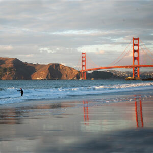
Top Photo: Emeryville Crescent by Karl Nielsen