


King Kong Levee: Two Miles Done, Two To Go
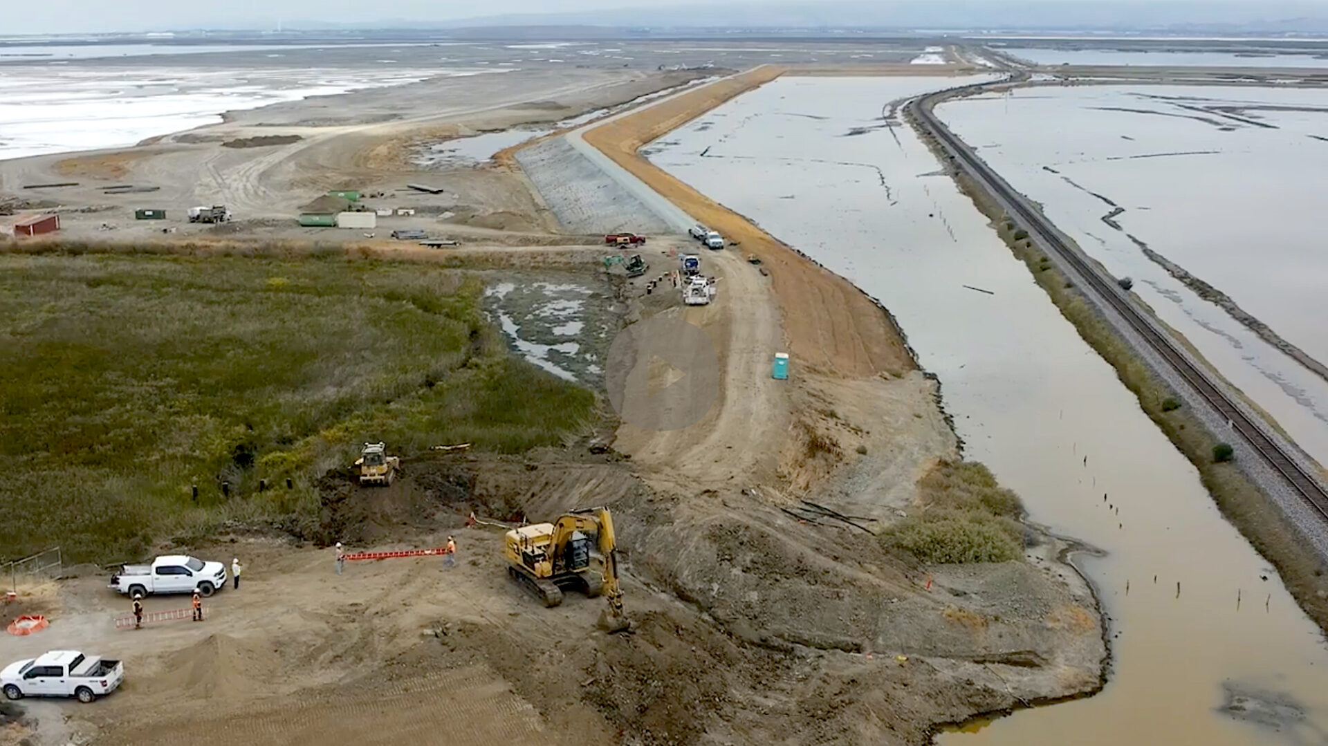
South Bay shoreline levee. Photo: Paola Reyes, Valley Water
Compared to the myriad mini-levees planned around the Bay in 2025, the South Bay’s growing shoreline levee stands out for its sheer scale and engineering.
This is no mere mound of dirt, like the 19th century earthworks still keeping the Bay out of pastures and local salt ponds, nor an experiment in how to use wastewater to irrigate new gray-green levees and filter out nutrients while protecting sewage treatment plants from sea level rise.
These two miles of 15-foot-tall, 16-foot-wide-at-the-top levee are of the more traditional Army Corps, FEMA-approved style: a major, multi-benefit flood control project designed to protect the oft-water-logged town of Alviso and parts of San Jose. This September marked completion of Phase 1 after 20 years in planning, development, and construction. The entire project, which will stretch from Alviso Slough to Coyote Creek, is expected to be completed by 2035 (provided additional funding is forthcoming).
Richard Santos grew up in the tiny fishing town of Alviso and remembers the floods in the 1960s, ’80s, and 1995. “It wasn’t just the water, but the damage and fear they brought. This project is more than infrastructure; it’s an important step toward peace of mind, safety, and confidence for our community,” says the Valley Water board director.
“As extreme weather and climate change-related emergencies increase in frequency, I am glad to see these life-saving protections for San Jose residents completed,” says Rep. Zoe Lofgren (CA-18).
To date, the $545 million project has required complex collaborations among local jurisdictions and partners (Valley Water, the Army Corps of Engineers, the California Coastal Conservancy, the Don Edwards National Wildlife Refuge, the city of San Jose, a railroad, the local parks district, and more). Eventually, the project will also enable the restoration of almost 3,000 acres of tidal wetlands on former salt ponds and completion of the Bay Trail through the area.
More importantly, it offers a tangible on-the-ground reminder of the scale of project necessary in the future as the region looks to protect airports, urban waterfronts, bridge touch-downs, and shoreline freeways from the steady rise of the Bay due to global warming.
“No project on the San Francisco Bay shoreline is easy,” says the Conservancy’s Amy Hutzel. “It’s always a complicated mix of jurisdictions and landowners and utilities, infrastructure and communities, all with lots of different needs. The Shoreline Project, I think, is a really great model of what we can do here.”
Next steps include constructing and revegetatating an ecotone along the levee, which will provide habitat for wildlife, and completing the remaining two miles of levee.
Other Recent Posts
Building Sustainably with Mass Timber
This building method can help clear forests of smaller trees that burn easily while also reducing the carbon footprint of new homes and offices.
Hardscapes That Filter Rain
Heavy rain can overwhelm storm drains and pollute waterways, but materials like permeable pavements help filter runoff and prevent flooding.
The Gray-Green Alchemy of Baycrete
Baycrete is a nature-based hybrid of concrete, shell, and sand designed to attract oysters and create shallow water reefs in SF Bay.
Tools Tweak Beaver Dams
Humans find ways to co-exist with beavers, tweaking dams to prevent flooding and create more climate resilience.
Hopes and Fears for Sierra Snowpack
February’s drought and deluge confirms that uncertainty may be a given for California snowpack, western water supply, and wildfire risk.
Errands by E-Bike
Electric cargo bikes are climate-friendly car replacements for everyday activities, from taking the kids to school to grocery shopping.
A Rare Plant Tough Enough to Save the Future Bayshore
Sea-blite can thrive in adverse conditions, buffer shores from waves, hold sand and soil in place, and clamber up eroding cliffs.
MORE
- Delivering Tunnel Muck to South Bay Marshes, August 2024
- A South Bay Levee Breaks Ground, April 2022
