


Mapping Those Most At Risk
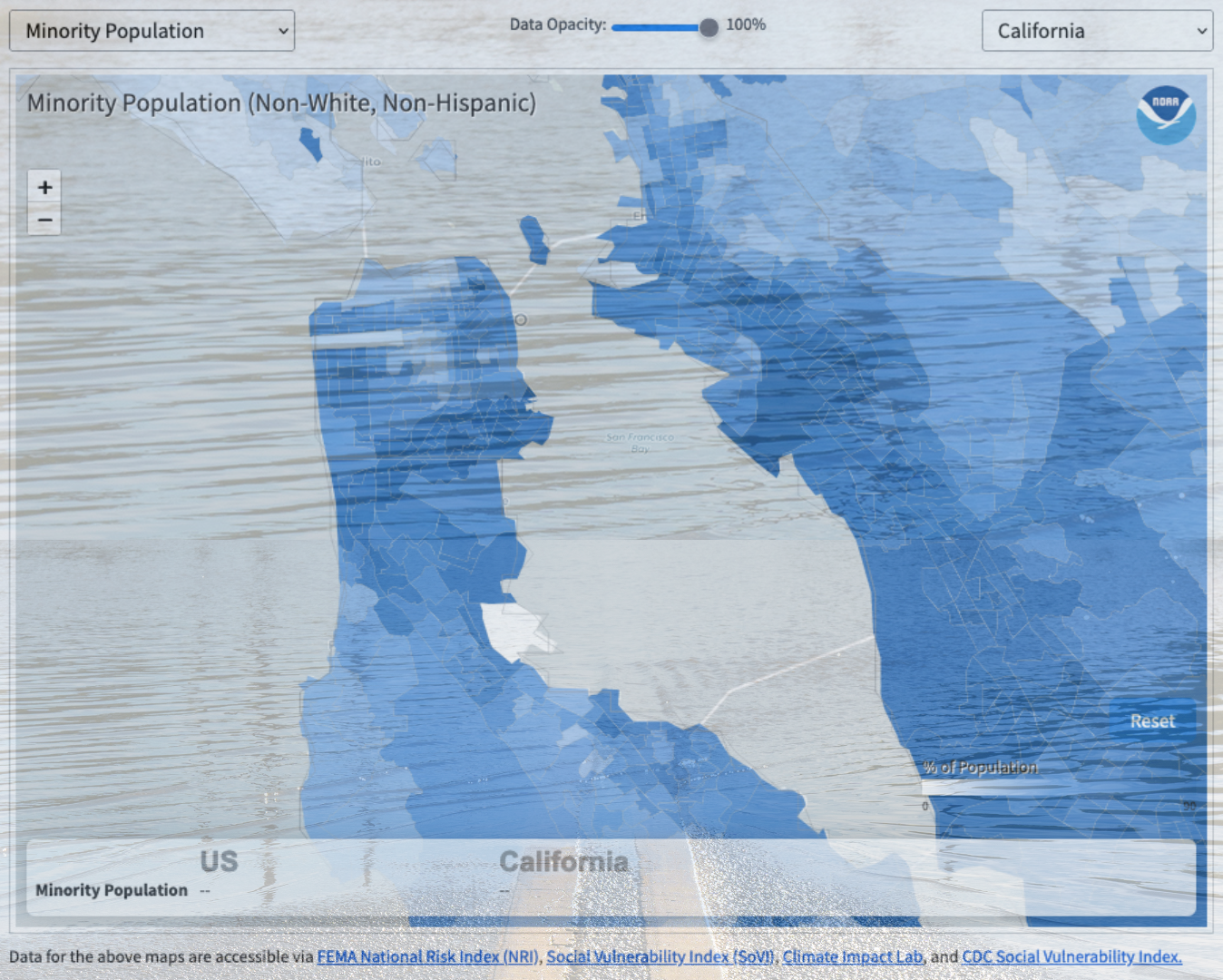
When planning for climate disaster, many federal agencies assess risk on the scale of cities and counties. But in reality, neighborhoods within a city are impacted very differently from one another. A flood that hits Bayview-Hunters Point in San Francisco would pummel a dense, 96% minority community with a poverty rate nearly three times as high as the county average. That same flood in the Marina District would encounter a spread-out, predominantly white, and highly educated population with an average salary nearly ten times greater than Bayview-Hunters Point’s — making the area far more able to withstand the flood and bounce back.
With the National Oceanic and Atmospheric Administration’s recent update to their long-running Billion Dollar Disaster Map, urban planners and citizens can see for themselves how disaster risk and vulnerability vary at the much finer “census tract” scale, representing about 4,000 people in a geographic area. Using the tool to look at “hazard risk” and “social vulnerability,” one can see how frontline communities like San Jose’s Alviso, Marin City, the San Rafael Canal District, East Oakland, and others stand out in stark contrast to the wealthier, whiter neighborhoods around them. The tool shows which census tracts have a significant number of people with characteristics that contribute to social vulnerability — for instance, those without vehicles, senior citizens, or the mobility-challenged. Or race, income, and educational level, which correlate with lower access to essential government programs and services that are essential to helping people and communities rebuild after a disaster.

As risk maps go — and there are an overwhelming number out there — NOAA’s is still a little clunky. The census tract view is hidden in a drop-down menu above and to the right of the map, and to look at historic flood hazard risk one has to manually de-select all six other hazard types. The Bay Conservation and Development Commission’s regional Community Vulnerability map is even more granular, analyzing vulnerability at the small “census block” scale (geographic areas of 3,000 people or less), and it also indicates contamination exposure. But hopefully NOAA’s update represents progress toward seeing pre-existing risk and vulnerability disparities within a city or county, and taking ameliorative steps before the next disaster exposes and widens them.
Other Recent Posts
Wild Pigs Rough Up Bay Area Greens
They tear up landscapes in search of food, prey on native wildlife, and damage streams, and warming could bring them closer to urban areas.
Delta Residents Absorb the Flood Challenge, And Choose Different Ways to Act
Graduates of a shoreline leadership program in Contra Costa County recently pitched their ideas for sea level rise education and adaptation.
Strong Leader, Light Touch: Caitlin Sweeney
Ahead of her retirement earlier this month, the Estuary Partnership director sat down with KneeDeep to discuss her achievements and the future of the Bay.
Unmasking Regionalism
Regional leaders say the Bay Area has built ambitious climate resilience plans. Now comes the harder task: funding and implementing them.
Pacheco Pass Is Getting a Second Wind
In Pacheco Pass, a decades-old wind farm is getting an upgrade that will double CleanPowerSF’s wind energy.
Climate Change, A Scorpion’s POV
From the Sierra Nevada to the Mojave Desert, the state’s native scorpions are losing habitat as heat, wildfires, and development reshape ecosystems.
12 Creek Types: Which One Is In Your Backyard?
Geomorphologist Gregory Pasternack and his team documented 12 types of Bay Area creeks to help residents protect themselves from flood threats.
Could Avocados Be A Transformational Fruit for the Bay Region?
Local growers and activists are planting avocado trees to build climate resilience, local food systems, and alternatives to imported fruit.
Radar Gap Filled on Marin Mountaintop
A new weather radar installation will help the region’s northern counties read incoming storm clouds, hours before they drop their rain.
The Climate Questions Facing Bay Area Voters This Spring
Important details about votes on transit funding, open space preservation, wildfire prevention, and earthquake prep this Election Day.

