


Weaving Fire Protection Out Of What’s Already There
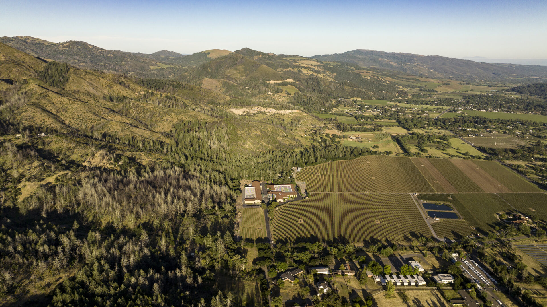
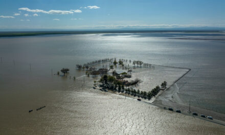
In the hillsides above Sonoma Springs, a patchwork of vineyards and oak woodlands already does something remarkable: it slows wildfire. The challenge is figuring out how to stitch together this natural advantage with the surrounding land into something that can protect an entire community.
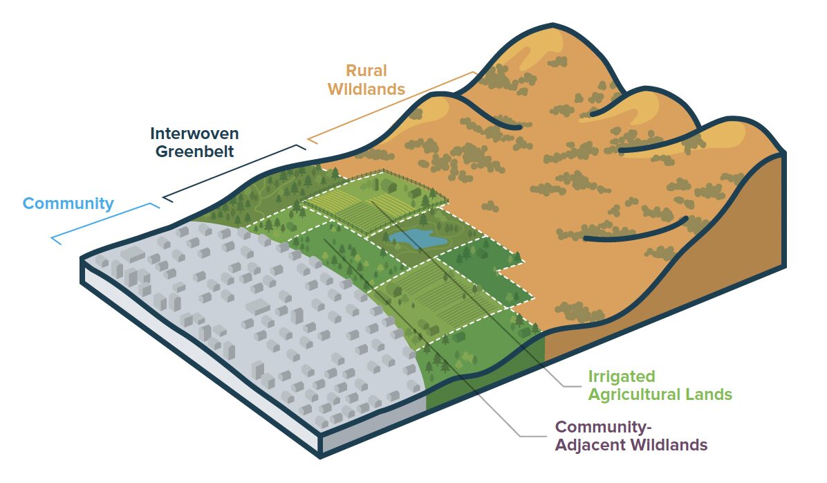
That’s the puzzle the Greenbelt Alliance tackles in their latest report, and the solution they’ve landed on is refreshingly pragmatic. Instead of trying to buy up and convert a continuous ring of publicly owned greenbelt — impossibly expensive in places where houses nestle between working vineyards and private woodlands — they propose knitting together what’s already there. They call it the Interwoven Greenbelt Buffer: a mosaic of irrigated farmland, managed grasslands, and strategically thinned forests that collectively mimics the protective effects of a traditional greenbelt.
The pilot site reveals why this matters. Sonoma Springs is typical of vulnerable communities across the West: dense residential development bleeding into hillsides owned by dozens of small private landowners, with narrow evacuation routes and a population that includes many renters and non-English speakers who face extra barriers to preparing for fire. One in eight Californians now lives in the most dangerous fire zones, and insurance companies are bailing.
Art: Greenbelt Alliance
Other Recent Posts
New Study Shows Rain Gardens Filter Chemicals Out of Stormwater
Scientists found rain gardens dramatically reduce toxic chemicals in stormwater while providing biodiversity and cooling.
The Tricky Art of Growing Oysters in the Lab So They Can Survive in the Field
The Nature Conservancy, the Amah Mutsun Tribal Band, and others are growing oysters in the lab and planting them in the wild in estuaries around San Francisco Bay.
Printing Without Plastic: The Vintage Machine Winning Over Eco-Conscious Artists
This comic guide to risograph printing explains how the 1980s Japanese machine cuts energy use and avoids plastic toner.
East Bay Kids Fight Extreme Heat in their Schoolyards
Many California schools are ill-equipped to tackle heat, with many campuses lacking sufficient tree coverage. These students are fighting to change that.
How a North Bay Regional Park Helped Me Reconnect With Nature — and Myself
A young Fairfield resident reflects on how hiking during the pandemic became a refuge from digital overload and the growing realities of climate change.
Wild Pigs Rough Up Bay Area Greens
They tear up landscapes in search of food, prey on native wildlife, and damage streams, and warming could bring them closer to urban areas.
Residents Chose Different Ways to Respond to Contra Costa Flood Challenges
Graduates of a shoreline leadership program in Contra Costa County recently pitched their ideas for sea level rise education and adaptation.
The report breaks the landscape into four zones, each with its own fire personality and management needs. The Community Zone, the residential core, needs widespread home hardening and defensible space. The Community-Adjacent Wildlands Zone faces the biggest challenges for resilience, with steep slopes and many privately-owned parcels. The Agricultural Zone includes the irrigated vineyards that proved their worth during the 2017 Nuns Fire in Sonoma, and can serve as a crucial fire break. And the Rural Wildlands Zone is a critical habitat and migration pathway with fire-adapted species that can benefit from prescribed burns.
Greenbelt Alliance lays out examples of what it will take to make this work: funding mechanisms like assessment districts or insurance partnerships, policy tools like overlay zones, and a coordinating body — perhaps a Fire Safe Council, homeowner’s association, or joint powers agreement — to herd all those private landowners toward collective action. It’s complex, admittedly. But it’s easier than relying only on land acquisition and easements — and it’s a lot easier than living in the path of fire without help.
