


Whiplash from Atmospheric Storm Hits San Rafael

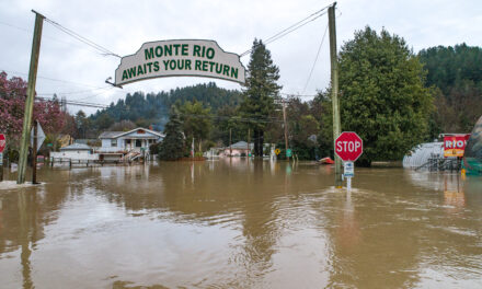
Late October’s atmospheric river storm dumped record-breaking amounts of rain across the Bay Area, leading to flooding, fallen trees, mudslides, and other damage. Flood sirens whooped as residents in low-lying areas made preparations such as moving cars and stacking sandbags. Even so, there were reports of evacuations, street closures, and calls to shelter in place around the Bay, including in Santa Rosa, San Mateo, and San Anselmo.
Overall, the whiplash-inducing arrival of the unusually early storm smack into an ongoing drought mitigated the flood impacts—the soils had not yet become saturated, and were able to absorb more of the rainfall.
“If this event happened mid-winter in a wet year, it would have been a very different story,” says Jack Hogan, a climate change risk and resilience engineer with the San Francisco consulting firm Arup who observed the storm unfold from his home in Marin.
“About 12 hours before the storm on Saturday my daughter was walking in the creek behind Peri Park in Fairfax, which was a trickle at the time and then rose by about eight feet during the storm,” Hogan says. “We were texting friends most of the day to check on how they were doing.”
Marin County’s geography features short, steep watersheds, where water moves fast downhill from open space in the ridges to cities in the flats. Luckily the reservoirs up top were empty, catching most of the downpour before it entered creeks and drainages.
“The biggest casualties were unprepared private construction sites,” says Rob Carson, program manager for the Marin Countywide Stormwater Program. “But if that amount of water had fallen after the New Year, or when reservoirs were full and the soil saturated, it could have been catastrophic. We couldn’t have absorbed it downstream.”
Neither reservoirs nor stormwater facilities were designed with projected future climate conditions in mind. Nor are shoreline protections for Marin residents living along the Bay ready for what’s coming: water arriving from all sides.
“There was a high tide in the middle of the heavy rainfall, which meant the creeks struggled to drain to the bay and started backing up,” Hogan said. “This gives us a glimpse into what even milder storms would look like throughout the Bay in the future as sea levels rise.”
In San Rafael, for example, some roadways were under two feet of water by midafternoon. “The flooding is anticipated to worsen due to another high tide, in addition to the rainfall levels from the atmospheric river,” the San Rafael Police Department announced in a midday advisory. Residents were advised to stay home and avoid all but essential travel.
Other Recent Posts
Wild Pigs Rough Up Bay Area Greens
They tear up landscapes in search of food, prey on native wildlife, and damage streams, and warming could bring them closer to urban areas.
Delta Residents Absorb the Flood Challenge, And Choose Different Ways to Act
Graduates of a shoreline leadership program in Contra Costa County recently pitched their ideas for sea level rise education and adaptation.
Strong Leader, Light Touch: Caitlin Sweeney
Ahead of her retirement earlier this month, the Estuary Partnership director sat down with KneeDeep to discuss her achievements and the future of the Bay.
Unmasking Regionalism
Regional leaders say the Bay Area has built ambitious climate resilience plans. Now comes the harder task: funding and implementing them.
Pacheco Pass Is Getting a Second Wind
In Pacheco Pass, a decades-old wind farm is getting an upgrade that will double CleanPowerSF’s wind energy.
Climate Change, A Scorpion’s POV
From the Sierra Nevada to the Mojave Desert, the state’s native scorpions are losing habitat as heat, wildfires, and development reshape ecosystems.
12 Creek Types: Which One Is In Your Backyard?
Geomorphologist Gregory Pasternack and his team documented 12 types of Bay Area creeks to help residents protect themselves from flood threats.
Could Avocados Be A Transformational Fruit for the Bay Region?
Local growers and activists are planting avocado trees to build climate resilience, local food systems, and alternatives to imported fruit.
Radar Gap Filled on Marin Mountaintop
A new weather radar installation will help the region’s northern counties read incoming storm clouds, hours before they drop their rain.
The Climate Questions Facing Bay Area Voters This Spring
Important details about votes on transit funding, open space preservation, wildfire prevention, and earthquake prep this Election Day.

Corte Madera day of the storm. Courtesy R.J. Suokko, Public Works, Corte Madera.
Hurricane Sandy on the East Coast in 2012 offers an example of flooding that was magnified due to its confluence with a high tide, says Katy Serafin, an assistant professor with the University of Florida (and formerly a postdoc at Stanford) whose research focuses on compound flooding events such as this one.
The Bay Area has two high tides each day, of different heights, and at some times of year tides can be much higher or lower. “While the famously high ‘king’ tides tend to occur in December and January in California, other processes such as storms and seasonal water temperature changes also lead to high water levels in the fall—and both of these time periods tend to coincide with stormy seasons where heavy precipitation and atmospheric river events occur,” Serafin says.
This type of confluence happens more often than people think, Hogan notes. “Standard engineering projects in coastal areas generally don’t account for those two events lining up, but they actually do line up quite a bit because tidal frequency is fairly short and storms that cause this amount of flooding are fairly long,” he says. This multi-factor flood assessment has, to date, rarely been included in urban planning and development.
Serafin agrees: “We often plan for extremes caused by only one type of process in isolation, like extreme rainfall or extreme coastal sea levels.” Climate change is also altering the behavior of these processes – both individually and how they co-occur, she adds.
“It was pretty startling to see the most populated city in Marin have to be partially closed down in the middle of October,” says Hogan. “Even if our home wasn’t flooded, we were still affected because our nearby downtown areas were, and we were getting Nixle alerts to stay home because roads were underwater.”

