


Two Workshops Daylight Alameda-Oakland Shore Solutions

In a set of two online workshops in early December, the Oakland Alameda Adaptation Committee laid out draft plans and design possibilities for adapting Bay Farm Island and the Oakland-Alameda estuary to sea level rise.
Alameda — coastal, low-lying, and built on fill — is vulnerable to flooding from multiple sources, including flooding from the Bay, rising groundwater, and increased rainfall. “If we simply built a wall around our communities to keep the Bay out without addressing stormwater and groundwater, we could unintentionally create a bathtub that fills with water and floods us anyway,” said Kris May, an engineer with Pathways Climate Institute and a project consultant, in the Oakland-Alameda workshop.
The near-term plans, designed to have a 35- to 50-year project lifespan, are preparing the area for two feet of sea level rise. The projects must also pave the way for long-term plans that will have to account for between 3.5 and 7 feet of sea level rise.
The OAAC, a coalition of shoreline community and agency partners, has a tricky task: develop near-term adaptations with the potential for further future adaptability. “As sea levels continue to rise, future generations — our children, their children — will have to adapt again,” said May in the Bay Farm workshop, which had about 100 attendees. “So we need to design with those long time horizons in mind.”
The proposed plans apply a patchwork of different strategies, including raising the grade of the shoreline, building seawalls and levees, relocating things (mostly parking lots), and marsh expansion.

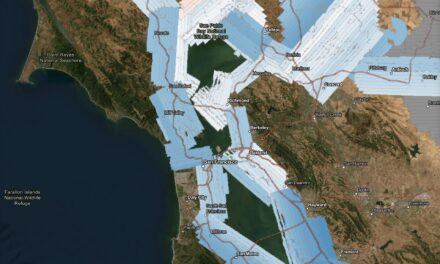
The near-term adaptation concept for one side of the Oakland Estuary, from Bohol Circle Immigrant Park to Shipways. Art: OAAC
“Each neighborhood has its own unique vulnerability profile, so we really have to understand these vulnerabilities at that neighborhood scale and engage with the communities to develop solutions,” said May.
Some of the proposed designs combine traditional engineering with nature-based solutions. For example, the designs for Bay Farm Island include levee improvements, storm drain modifications, a new tide gate and pump station, and expanding the fringe marsh at Veterans Court. Along the Oakland-Alameda estuary, a proposed concept builds living sea walls along a stretch of shoreline that transitions to a levee near the Shipway redevelopment project.

A FEMA grant could fund six project areas on Bay Farm Island. Art: OAAC
So far, only the planning process has been funded. The City of Alameda and its partners have applied for a $55 million FEMA BRIC grant that would cover design, engineering, permitting, and construction for six project areas on Bay Farm Island. OAAC is seeking up to $4 million in federal community project funding and $30 million from the Water Resources Development Act to design and build the Estuary project.
The next opportunities for public comment on these plans will be at an Alameda Climate Action and Resiliency Plan Zoom Workshop on December 18th and a City Council meeting on January 21.
Top Photo: King tide along Alameda shoreline, Nov 16, 2024 by Maurice Ramirez
Other Recent Posts
Wild Pigs Rough Up Bay Area Greens
They tear up landscapes in search of food, prey on native wildlife, and damage streams, and warming could bring them closer to urban areas.
Delta Residents Absorb the Flood Challenge, And Choose Different Ways to Act
Graduates of a shoreline leadership program in Contra Costa County recently pitched their ideas for sea level rise education and adaptation.
Strong Leader, Light Touch: Caitlin Sweeney
Ahead of her retirement earlier this month, the Estuary Partnership director sat down with KneeDeep to discuss her achievements and the future of the Bay.
Unmasking Regionalism
Regional leaders say the Bay Area has built ambitious climate resilience plans. Now comes the harder task: funding and implementing them.
Pacheco Pass Is Getting a Second Wind
In Pacheco Pass, a decades-old wind farm is getting an upgrade that will double CleanPowerSF’s wind energy.
Climate Change, A Scorpion’s POV
From the Sierra Nevada to the Mojave Desert, the state’s native scorpions are losing habitat as heat, wildfires, and development reshape ecosystems.
12 Creek Types: Which One Is In Your Backyard?
Geomorphologist Gregory Pasternack and his team documented 12 types of Bay Area creeks to help residents protect themselves from flood threats.
