


A Ramble Around Pacheco Marsh

Stepping onto the spanking new Pacheco Marsh trail near Martinez for the first time on May 1, I was struck by the contrast between nature and human industry all around. What might normally seem ugly to look at — the Marathon Oil refinery, a Contra Costa sewage plant, freeways, bridges, cargo ships — didn’t exactly look pretty but did look interesting, set off as they all were by the verdant marshes and golden flowers at my feet.
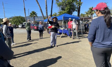
The occasion was a ribbon cutting for the new Pacheco Marsh park shepherded into being over many years by the local John Muir Land Trust, which one person I interviewed that day called a “lean, mean, conservation machine.” We were to walk or ride a golf cart to the site of the ceremony, sample a breakfast buffet of muffins and chicken salad on rolls, hear speeches from supervisors and partners and NGOs and donors, watch as officials wielded oversized, photo-worthy scissors to cut the green tape, and then be set free to explore the beautiful new trail through the marsh.
Just four years before, on an earlier reporting visit, there hadn’t been a cattail clump or cordgrass stand or pickleweed patch in sight. By 2021, the site had been massaged by heavy machinery into the underlying shape of a marsh. In October of that year, I watched a backhoe scoop a hole in the levee and let the tides onto the land (below).
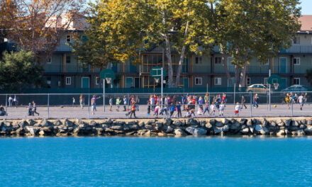
On this May 2025 visit, the sky was blue, the sun bright, and the breeze brisk, a perfect morning for a wander by the Bay. My walking companion, reporter Robin Meadows, and I ambled down the gravel trail toward a podium far in the distance, while more elderly folk favored the even ground of the ADA-rated concrete pathway to our left.

It takes generations to do a project this ambitious and more than one writer to cover it. For decades, Walnut Creek had a problem with flooding, and in the early 2000s district engineer Paul Detjens set out to fix it. Over the years, the project involved getting the failing flood control channel out from under Army Corps jurisdiction, setting back levees, and reconnecting the creek to its watershed, floodplains, and historic mouth on the shores of San Francisco Bay. I first wrote about it in a flood control story for Bay Nature in 2015, and Robin Meadows then wrote about opening the creek mouth for Estuary News in 2020. By 2023, all the innovations to the flood and stormwater systems were done, leaving only the task of putting the cherry on top: inviting the public to recreate around the new creek mouth. This 2025 opening of the new marsh park, with 2.5 miles of trail, benches and pedestrian bridges, bathrooms, and a launch for human-powered boats, among other amenities, was what we were there to experience.

It wasn’t long before we came upon Paul Detjens himself, now retired from the Contra Costa County Flood Control District, but still wearing his signature orange shirt (above). He was chatting with one of the original project’s environmental designers, ESA’s Michelle Orr, also wearing orange. Together, in the Walnut Creek project, they had introduced a whole new flood control paradigm. Robin and I gravitated toward them like groupies: when you get a quotable source who not only takes on unusual projects but also returns your calls, you stick to them. After breakfast, we settled in to hear the speeches. Linus Eukel of the John Muir Land Trust, the lead NGO for the park project, spoke with palpable sadness about the current divisions in the country. “Conservation has suddenly become a one-party issue, when it used to always have bi-partisan support,” he said, pointing out how the Pacheco Marsh project, by contrast, brought so many people together: “We protect nature because we love the land, and we are called upon to love one another.”

After an hour of speeches, Robin and I ate the cherry on top: a walk on the new side trail looping through the marsh. At the outset, visitors will find an array of unintrusive but educational signage set on posts and surrounded by flowers (above). I’d already seen a white kite on the hunt, with its streamlined wings, and heard the blackbirds chirping in the reeds. The marshes will also host, planners hope, a chicken-shaped threatened marsh bird called the black rail, as well as migrating ducks and their food: the plankton, clams, worms, juvenile fish, and other life in the sloughs and oozes. One sign calls attention to the outfall of the local sewage plant, where cleaned wastewater gets released into Carquinez Strait. Indeed, as we continue our ramble, other signs of water and oil refining infrastructure garnish the edges of the park: white pipelines, sump pumps, railroad tracks, shore cranes. All at the intersection where — as Supervisor John Gioia pointed out in his speech that day — “Contra Costa’s largest watershed meets the West Coast’s largest estuary. To think it used to all be a dumping ground…”

Near the first bridge, where the green ribbon had long since been removed, we came upon another Contra Costa Supervisor, Shanelle Scales-Preston from Pittsburg (above). She described the new park as a “community treasure” with its flat ADA-friendly trail, bird life, and cool breeze in the heart of an industrial area. “This is a gentle space where families and elders can enjoy nature together, where we begin to achieve some environmental equity in our county,” she said. “This was $11 million well spent by the SF Bay Restoration Authority,” added Gioia during his podium speech, pointing out the investment of regional tax dollars in wetlands and open space for small communities surrounded by big industry. The entire marsh restoration and public access improvements cost about $25 million. “Though it was a really big project, it still felt really grassroots,” said Gioia, who now chairs the restoration authority.

The trail bridges (above) are striking. Bright shiny aluminum against the green marsh and blue sky. Almost blinding when the sun hits another bridge in the far distance. We asked Drew Goetting, whose firm Restoration Design Group designed the bridges and trails for the new open space, why the bridges looked so different — almost like a toppled electrical tower — from the wood posts and concrete pilings one might normally expect on a park trail. “Bay mud lacks bearing capacity,” he said. “If you put a pier in the mud to hold up a heavy bridge it would just sink.” RDG’s design called for lightweight bridges, so aluminum was used, and also “spread footings that act like a snowshoe,” he says. “Fortunately, these bridges are very durable, and can be raised as the sea level increases over the next 50 years.”

Another special amenity in this new park is a boat launch and two-mile kayaking loop through wetlands. The sight of the launch (above) reminded me about the ambitious effort to create a water trail for small non-motorized vessels like kayaks around the Bay, an aquatic parallel to the Bay and Ridge Trails. So when I saw avid kayaker and paddleboarder Ben Botkin at the breakfast buffet, I asked him about progress and how Pacheco Marsh fits in. “I remember looking for a way to get out on the water here with my paddleboard years ago, but there was no access anywhere in this area,” said Botkin, who works for the San Francisco Estuary Partnership. He told me the new park is part of a Priority Conservation Area designated by regional agencies (MTC/ABAG) as a target location for wetland restoration, resilience to sea level rise, and recreation projects. The area’s designation came with a grant to help the land trust build public access amenities. Botkin hopes Pacheco’s shiny new kayak launch will one day join 54 other designated Water Trail sites across the Bay Area.

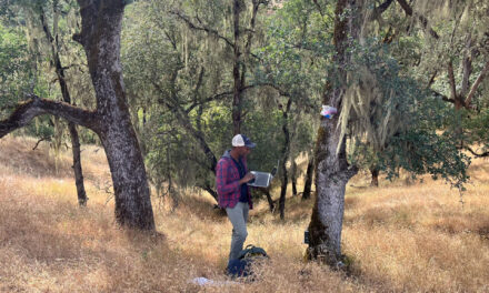
As we walk through rippling fields of marsh grasses, Robin remarks that I set a good pace, and I sneeze. And sneeze again. Just this little bit away from the edge of the Bay and the hay fever kicks in with a vengeance. I later identify one culprit as Phragmites (above), though I can’t tell if it’s the invasive or naturalized variety. Various white flowers — wild radish, pepperweed, elderberry — also release their irritants into the air as I speed up. By the time we get back to the trailhead, hand in our name-tag lanyards for recycling, visit the pristine port-a-potties, and oggle the arching shade structures for visitors, I am a hot mess with streaming eyes and a runny nose. I can’t wait to get in the car and turn on the AC. Robin makes a beeline for her white sedan — the one she says she can rarely pick out in any parking lot, there are so many. As we drive away, I can’t help marveling at how fast this rough weedy patch of shore has been transformed into a green park where schoolkids will come to learn about nature. As Contra Costa’s Paul Detjens reflected: “This was always a super popular project with the public.” And I can now see why.

All photos by Ariel Okamoto except the final one by Karen McDowell.
