


Three Ways to Feed the Marsh

“I’ve had conversations with resource managers across the state who have been interested in the project. We have a ton of lessons learned.”
Seal Beach is drowning. As a result of sea-level rise, subsidence, and limited sediment supply, much of the 920-acre National Wildlife Refuge in Orange County can no longer keep its head above water. Pacific cordgrass, normally exposed at low tides, is being completely inundated. Rare nesting habitat for the endangered light-footed clapper rail is disappearing at high tides. It’s a marsh manager’s worst nightmare, and a potential harbinger of things to come later this century for tidal wetlands up and down the state, including those in San Francisco Bay.
The problem at Seal Beach has been building for decades, and by 2016 managers knew they had to act—fast. But options for saving the existing marsh were limited. So on an eight-acre test plot they went for the Hail Mary: a promising yet unproven approach called “thin-layer placement,” which had never before been attempted in a California salt marsh.
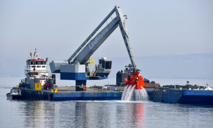
The process involved using pipes and hoses to lightly spray sediment from a nearby dredging project onto the project site, which was hemmed in by hay bales and sandbags. Contractors ultimately added eight to ten inches of sandy material across the site, a thickness that project manager Evyan Sloane of the California State Coastal Conservancy says was calculated to strike a balance between gaining as much height as possible and not suffocating existing vegetation.
Though it’s been practiced for decades in Louisiana and along the East Coast, thin-layer placement via hydraulic spraying has gained greater interest both nationally and locally in recent years. It’s seen as a potentially valuable tool for adding height to existing marshes that lack adequate sediment supply to survive subsidence and sea-level rise. And because it involves the careful application of slurried, or water-suspended sediment, thin-layer placement is thought to mimic the intermittent storm-driven deposition of large volumes of mud and sand atop healthy marshes, and thus allow for the natural recovery of existing ecology. How well and how quickly that happens is a matter of ongoing inquiry.
At Seal Beach, things didn’t go exactly as planned. Five years on, not only has the net elevation gain diminished to four inches due to compaction and further subsidence, but native wetland plants like pickleweed and cordgrass have not rebounded as rapidly as expected. “We had this idea that after two growing seasons, the site would be revegetated,” Sloane says. “The revegetation has been much slower to recover than we originally anticipated.” She attributes this to a mix of factors, including the thickness and characteristics of the new sediment layer, a low seed bank in the project area, and overly optimistic expectations.
But all is not lost. As an experimental pilot paired with extensive monitoring and active management, the effort has been quite successful. Sloane says it has already generated scores of lessons for future projects, not only at Seal Beach—where the U.S. Fish and Wildlife Service is already considering another, larger project to build upon the pilot—but throughout California. “I’ve had conversations with resource managers across the state who have been interested in the project,” Sloane says. “We have a ton of lessons learned.”

Seal Beach post placement in 2019. Photo: CSU Long Beach
In addition to the Seal Beach project, thin-layer placement has also been studied in recent years by the National Estuarine Research Reserve. Through a coordinated project launched in 2017, scientists at eight different marshes nationwide, including Manzanita Marsh in western Richardson Bay near Mill Valley, installed a series of tiny plots measuring 28 inches by 28 inches each, filled them with varying depths and types of sediment, and then monitored them over the course of three years.
Co-principal investigator Kerstin Wasson, who also serves as research coordinator at the Elkhorn Slough National Estuarine Research Reserve and is an adjunct professor at UC Santa Cruz, says initial revegetation was fastest in test plots with the least amount of sediment, just 2.75 inches. By the end of the study’s three-year time frame, deeper plots with 5.5 inches of sediment had caught up and fared about as well. But no plots with added sediment became as fully vegetated as reference plots.
These findings generally agree with those at Seal Beach: full plant cover may well return after the addition of a layer of sediment to support a drowning marsh—whether that means 10, 5.5, or 2.75 inches—but it won’t happen quickly, and could take a decade or more.
“You have trade-offs between long-term sustainability and speed of recovery in the short term,” Wasson says. “Are you trying to build the marsh high enough to withstand sea-level rise 100 years from now or to be fully vegetated one year from now?”

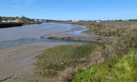
Thin-layer placement experiment on Deer Island, Marin County. Photo: Roger Leventhal
Hydraulic thin-layer placement has been attempted at a more real-world, though still pilot-level scale just once in the Bay Area, near Novato’s Deer Island. In 2016, the Marin County Flood Control District placed 12 to 18 inches of re-slurried sediment dredged from Novato Creek onto the adjacent marsh in order to help build its elevation in a manner mimicking natural processes. Though slow and expensive, the work was successful.
“The plants have gone right back through it,” says Roger Leventhal, a senior engineer with Marin County Public Works who designed and permitted the project. “It’s a good example of flood agencies trying to reuse sediment.”
Leventhal has also advocated for using the technique to help restore Marin’s Bothin Marsh, next to Manzanita Marsh in Richardson Bay and home to a popular segment of the Bay Trail that is routinely flooded by king tides and storm surges. Thin-layer placement is among a variety of approaches currently being considered by Marin County Parks and Open Space for Bothin, which is one of San Francisco Bay’s highest-profile at-risk marshes.
In its recent report Sediment for Survival, the San Francisco Estuary Institute highlights a looming shortage in the natural sediment supply needed by marshes and mudflats regionwide to gain elevation as sea level rises. Without successful placement of potentially hundreds of millions of tons of additional sediment sourced from navigation and food-control channels, dams, and upland sources, many existing wetlands will be lost.
Alongside thin-layer placement, two other, even less familiar ways of moving supplemental sediment onto stranded salt marshes are being considered for future use in San Francisco Bay. One, known as shallow-water placement, involves placing dredged sediment into the shallow subtidal zone and relying on wind and wave action to move it onto the mudflats and marsh. The other, known as water-column seeding, involves slowly releasing sediment at flood tide into marsh channels so that it is carried in on the tide and gently deposited along channels throughout the marsh system.

Jeremy Lowe, a senior environmental scientist with the San Francisco Estuary Institute, led a study in 2017 evaluating the feasibility of each of these three forms of “strategic placement” to inform future beneficial reuse of dredged sediment in the Bay. Thin-layer placement, he believes, may be ideal for the targeted filling of low spots in a marsh rather than covering tens or hundreds of acres in a blanket of mud. Water-column seeding is likely of even more limited applicability because of the technical challenges involved with getting sediment into a channel at the right time and rate, he says—but may be valuable in specific circumstances.
Shallow-water placement, meanwhile, most closely mimics natural processes and can move sediment over a larger area, but is also the least directed, he says. Since wind and waves do the heavy lifting, results may be unpredictable—with no guarantee that sediment will move into the targeted marsh in the desired quantity. Shallow-water placement may also temporarily increase turbidity in near-shore waters beyond typically allowed levels.
There’s actually one more option, Lowe says: none of the above. In some cases, it may be best to let existing marshes simply retreat and re-shape, he says. “It all fits into what our expectations are for marshes in the long term.”
In others, as Sediment for Survival makes abundantly clear, there simply may not be enough mud available. “At some point somebody’s going to have to make some choices,” Lowe says. “Maybe we should not be so extravagant in our designs for fill. We can’t just draw the line and expect to find the fill.”
Much of that fill—and thus the key to the long-term survival of some of our region’s marshes—lies in the hands of the U.S. Army Corps of Engineers. Currently, the majority of the material the agency digs up during routine dredging of federal channels is dumped at sea, due in large part to the high cost and technical difficulty involved in the beneficial reuse of dredged sediments. These challenges may be particularly pronounced when it comes to the precision and care required for more strategic placement of sediment onto existing marshes with minimal environmental impact.
Still, informed by Lowe’s report, former San Francisco Estuary Institute senior scientist Julie Beagle is now leading the Corps’ efforts at further pursuing strategic shallow-water placement of dredged materials in San Francisco Bay. The agency is conducting modeling to determine suitable sites in hopes of initiating its first project—ideally near a Corps-dredged channel—within the next couple years.
“There’s lots of ways to get sediment onto marshes, and we know that the Corps and everyone needs to reuse material,” Beagle says. “I think we need all tools possible, and we need the right tool in the right place. Our solutions are going to be different based on the problem and the setting. We need to pilot more of these tools so that as the century progresses, and we start to see the impacts of sea-level rise and the sediment deficit, we’ve got tools that can be deployed at the right time to give our baylands the best chance of survival.”
