


The Nuances of Tapping North Bay Sediment Supplies
How Adobe Creek and the Petaluma River can help three parcels, including a popular park, evolve into one resilient shore.
Any admirer of the Petaluma River will tell you it isn’t really a river. Indeed, the word doesn’t do justice to this 13-mile waterway that works in both directions, wending a serpentine course from the northwestern corner of the San Pablo Bay to the heart of downtown Petaluma and back again. Technically a slough with significant freshwater flows during the rainy season, it drains a 146-square-mile watershed yet runs brown with fine bay sediment all year long.
This confluence of creek and bay, fresh and saline, seasonal and tidal occurs across a vast expanse recognized as the second-largest remaining brackish tidal marsh on the West Coast, trailing only Suisun Marsh.
But not all is well on the Petaluma Marsh. Its original 16,000 acres have fragmented into a patchwork of small marshes totaling about 6,800 acres. Human and natural needs sometimes clash, particularly around wetlands, and nowhere is that more true than at Petaluma’s most beloved public open space.
Shollenberger Park, visited by hundreds of community members each day, sits at the heart of an ambitious, long-term proposal released in early February by the San Francisco Estuary Institute to improve the resilience and ecological functioning of a 484-acre swath of city-owned marsh using nature-based solutions. City planners, Tribal leaders, local environmental groups, and key regulators are all in support. Now they just have to sell the public on it.
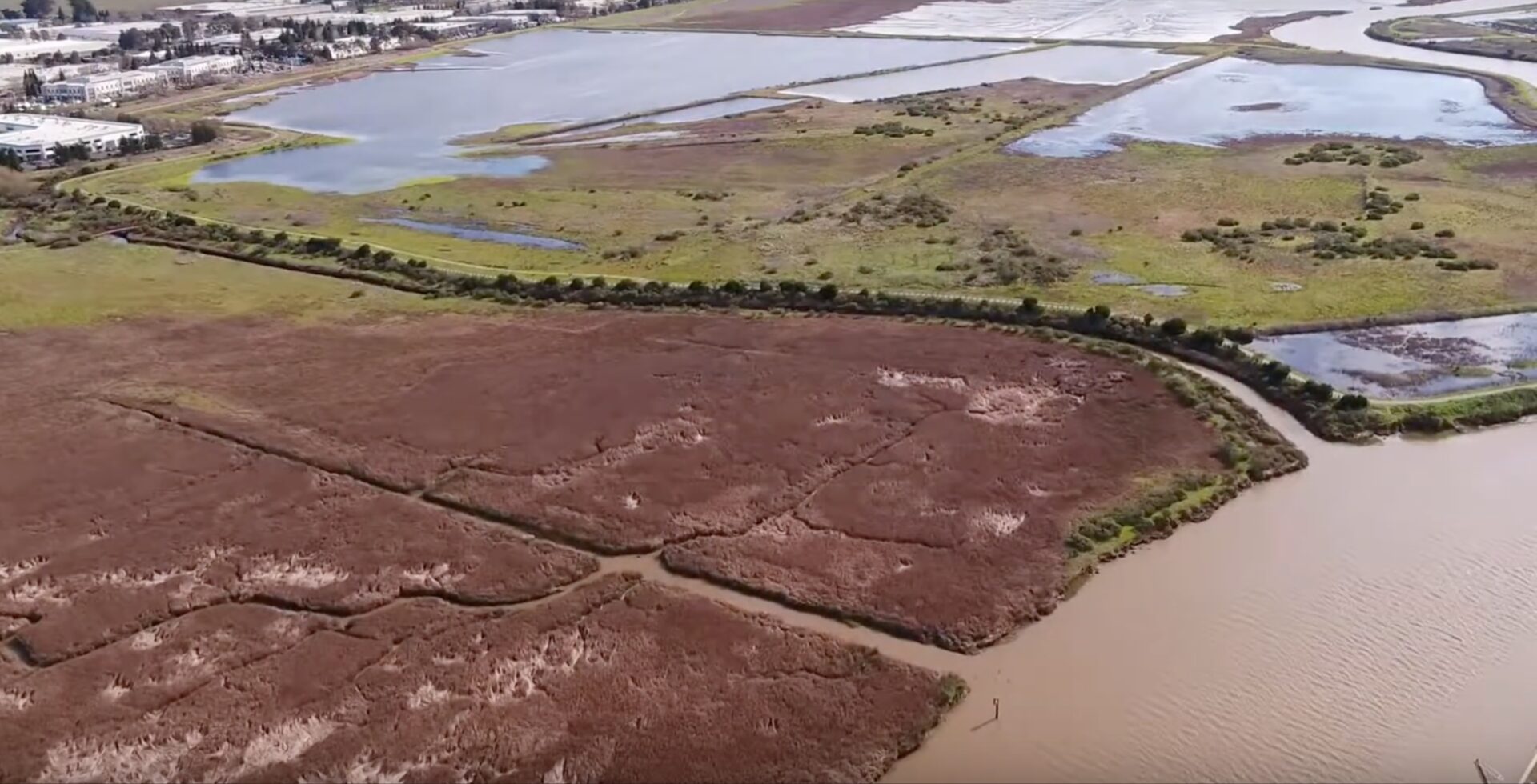
Aerial view of Alman Marsh (foreground), tree-lined Adobe Creek, and Shollenberger Park (seen in wintertime with seasonal ponds full). Photo: Philip Williams Associates
A Tale of Three Marshes
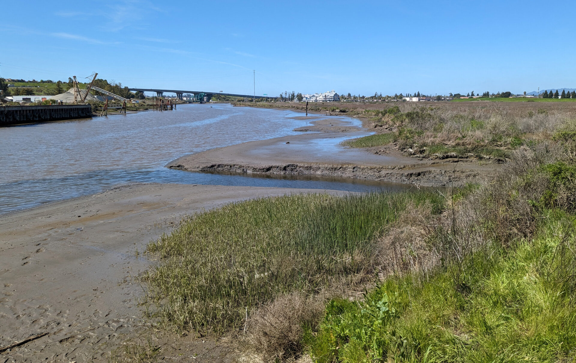
Shollenberger is not only a major draw for locals seeking fresh air, river views, and wildlife — it’s also, as part of a longstanding agreement with the U.S. Army Corps of Engineers, a dumping ground for mud dredged from the Petaluma River to keep it navigable. Walkers, joggers, and birders circle a man-made seasonal pond and central disposal area along a 2.15-mile loop trail over a levee that decades ago cut off the waterway from its former marsh.
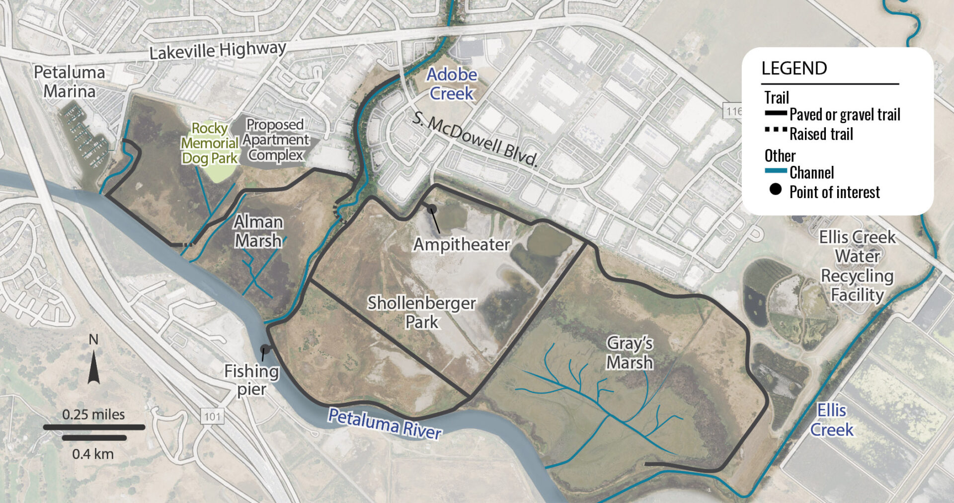
Current conditions within the project area. Map: SFEI
Just to the north at the adjoining Alman Marsh, the situation is only slightly better. Adobe Creek, one of the Petaluma River’s largest freshwater tributaries — which starts in a spring high on Sonoma Mountain overlooking the valley — travels across a compromised and divided marsh before meeting the river. Sediment and freshwater flows have been interrupted, and habitat degraded.
On the south side of Shollenberger is a third marsh in poor health. Previously diked and ditched for wheat and hay cultivation, Gray’s Marsh was unintentionally breached when a waterfront berm failed in 1998. Today it’s mostly mudflat, with some vegetation growing along its outer edge.
What’s more, climate change is coming for all three sites. None is in sufficient shape to be resilient to or keep pace with rising tides from an ecological and functional point of view. Nor are they set up to serve as a reliable buffer against flooding for the commercial and residential buildings backing up against them.
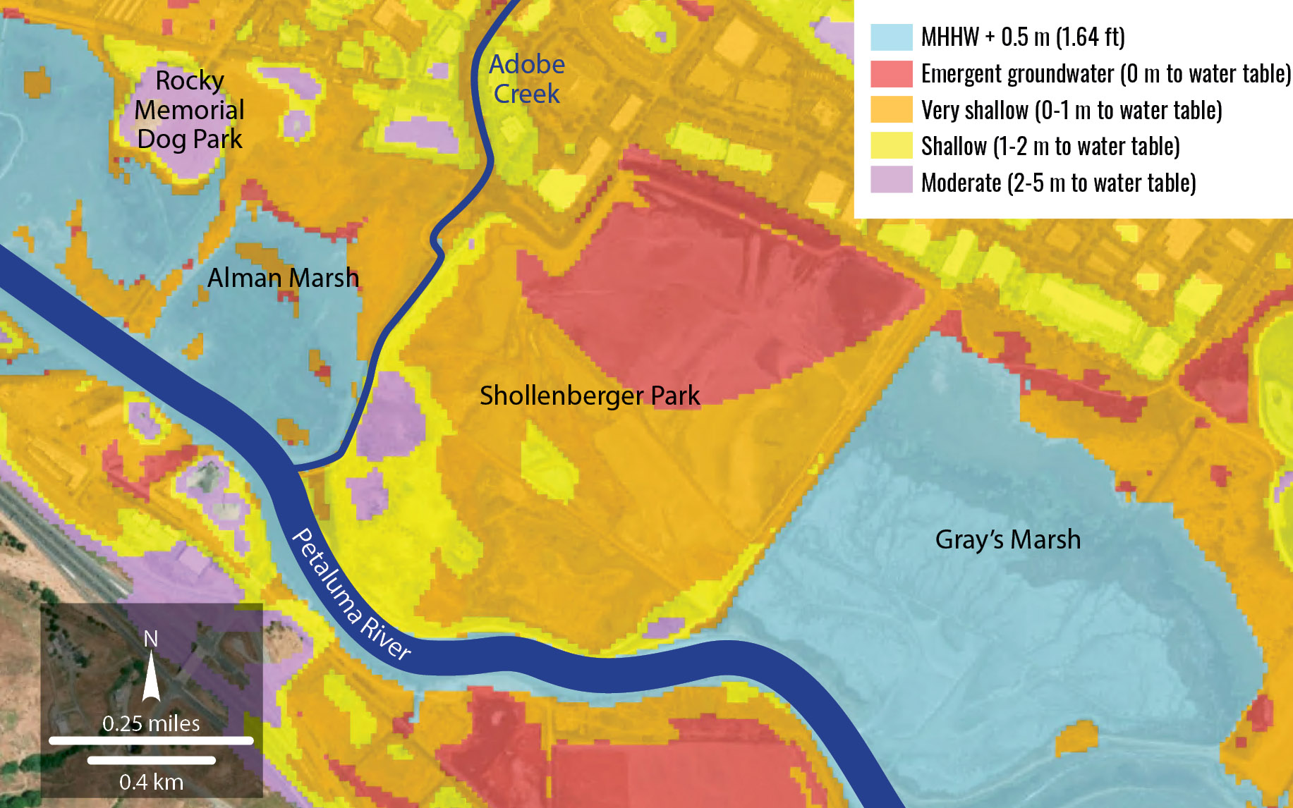
Project site with 1.6 feet of sea level rise. Map: SFEI
“We’re going to lose Alman Marsh for sure, and will lose parts of Shollenberger Park between now and 2050 to 2075,” says Petaluma Councilmember and Petaluma Wetlands Alliance President John Shribbs. “We’re going to lose them to sea level rise anyway, so we might as well start preparing now.”
It’s All About Sediment
At the core of the San Francisco Estuary Institute’s newly released vision for the three properties is, naturally, the single-most important ingredient in any marsh restoration project: sediment.
A component of SFEI’s broader, EPA-funded “Sediment Solutions” program, the report — officially titled Restoring Sediment Pathways: A Resilient Landscape Vision for the Adobe Creek Baylands — hinges on beneficial reuse of future dredged sediment from the Petaluma River to raise marsh elevations and build protective ecotone levees on their back ends to protect developed areas. It also proposes to reconnect lower Adobe Creek with adjacent marshland to restore natural sedimentation and accretion going forward.
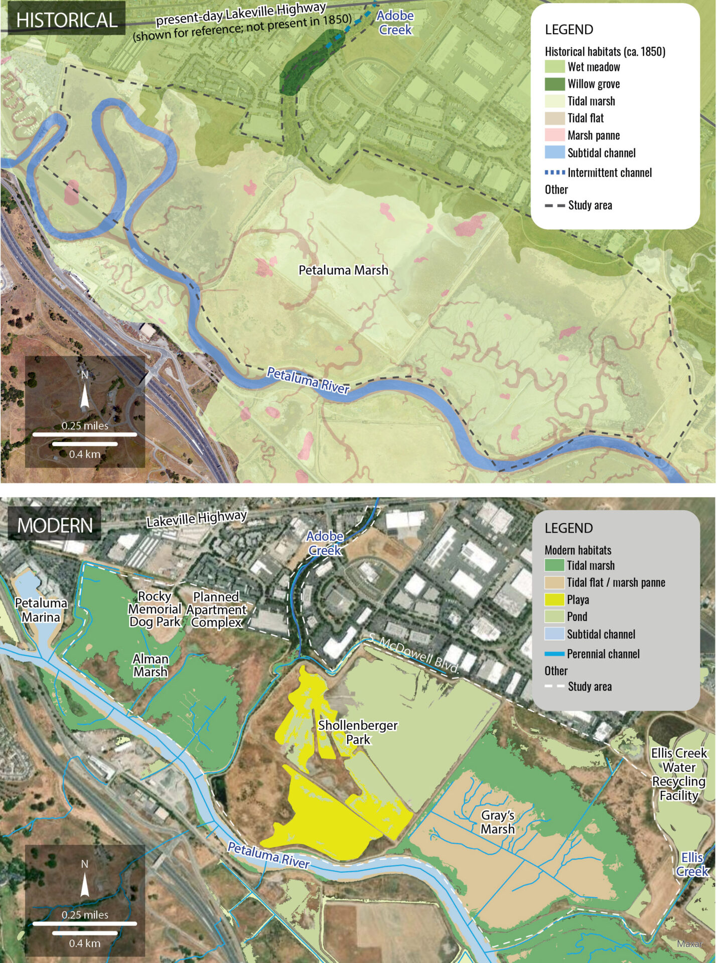
Modern and historical habitat types in study area. Map: SFEI
“It’s going to take a huge, huge amount of soil movement,” Shribbs says. “This is a major landscape transformation.”
It won’t all happen at once, and it won’t happen fast. The report describes a two-phase vision, the first of which could be implemented over the next decade or more, and the second, which focuses on Shollenberger Park, would occur in future decades, “potentially extending toward the end of the century,” the authors write.
SFEI Senior Scientist Scott Dusterhoff, one of the report’s senior authors, says this proposed timeline accounts not only for all the planning that still needs to happen, but also for forecasted rates of future sea level rise.
“If we start planning this project now, and this is just conceptual design, then 10 to 15 years from now this project could be going in the ground,” Dusterhoff says. “And by that time, sea level rise will be accelerating, and it will need more sediment. So we need to plan now to set our marshes up for success in the not-too-distant future.”
Once underway, the first phase as currently conceived involves a wide range of elements across all three marshes. These include removing previously placed dredge materials from the center of Shollenberger and using them as cover material for a new ecotone levee behind Alman Marsh; breaching the berm currently separating two patches of marsh at Alman; increasing connectivity between lower Adobe Creek and the marsh; and enhancing Gray’s Marsh to improve the flow of sediment and tides.
The second phase, even farther down the line, includes a suite of actions that will transform all 165 acres of Petaluma’s most beloved park. Shollenberger will be completely regraded to restore tidal connectivity with the Petaluma River, Gray’s Marsh, and Alman Marsh. A new seasonal pond will be added near the marsh edge, and a new ecotone levee constructed on the upland side.
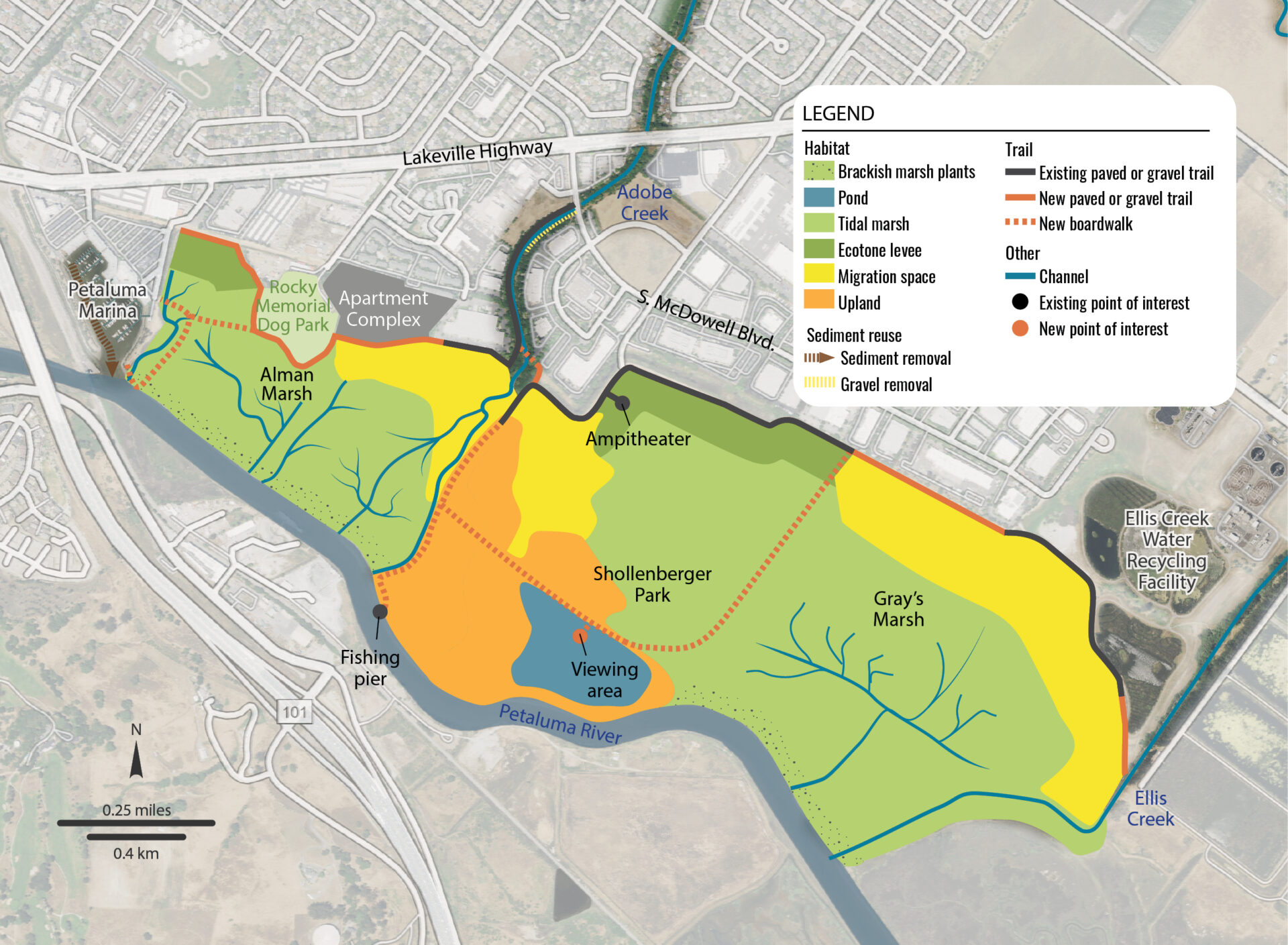
Future vision and proposed conditions. Map: SFEI
What will be lost in the process, however, at both Alman and Shollenberger, are the existing riverfront paths that make these spaces so popular. The trails are at risk either way, Shribbs says, but the task of communicating this to the public, and garnering support for preemptively (and at great cost) removing existing access to two of Petaluma’s most cherished assets, will fall on city leaders like him.
Access and Acceptance
For now, the plan is still largely unknown to the public. In February 2024, a local nonprofit called Friends of the Petaluma River organized a small community meeting to discuss the evolving vision for the marsh. In survey responses from 37 participants, maintaining and enhancing public access to trails and waterways emerged as a major concern. A second meeting and 71 more survey responses in April 2025 reaffirmed these findings.
“We heard consistently that access to the marsh was a huge priority for community members — maintaining that connection to the land, the ecosystem, the habitat, and the wildlife there,” says SFEI Associate Environmental Scientist Emma Sevier, the report’s lead author. “One thing that was really special that came out of our second community meeting was this conversation around what shoreline access might look like under rising sea levels and under a changing climate.”
Future public engagement — and indeed most further progress on the plan — hinges on the City of Petaluma’s ability to secure buy-in, literally and figuratively, from the Army Corps of Engineers.
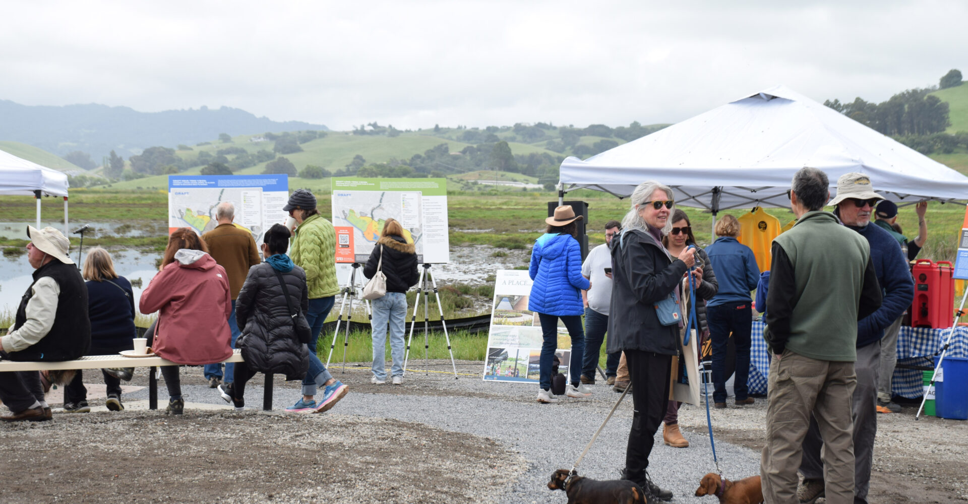
Community members view near- and long-term visions at Shollenberger Park in April 2025. Photo: SFEI
“The city is currently pursuing funding and coordination with the USACE for a feasibility study,” says Petaluma Director of Water Resources and Utilities Chelsea Thompson. “The goal of that study is to evaluate ecosystem restoration opportunities and re-envision the existing dredge disposal pond at Shollenberger for beneficial reuse, including potential use of dredged sediment to build up and support wetland restoration and improve habitat connectivity.”
Such a study “would build on the Lower Adobe Creek Baylands Vision developed by SFEI and help assess restoration alternatives, sediment management strategies, and nature-based approaches to improve wetland function and shoreline resilience,” Thompson adds.
Shribbs says the city should begin preparing its case now to convince residents that the loss of access proposed in the current plan will be offset by new riverfront trails elsewhere, and that the massive cost of completing the work will be cheaper than the alternative.
“This is such an important example for the entire Bay Area,” he says. “It’s a study to indicate what needs to happen, in the cheapest way possible, to save us from sea level rise. We’re in an excellent spot to demonstrate that, because we’ve got the right landscape to kind of say, ‘Hey, something could be done here to protect everything behind this area, and also the rest of the city, because you’re providing all the space for water to enter in.’
“Dealing with the public, and the public perception, that’s going to be critical.”
This story was supported by a grant from the North Bay Watershed Association.